Results for Mead
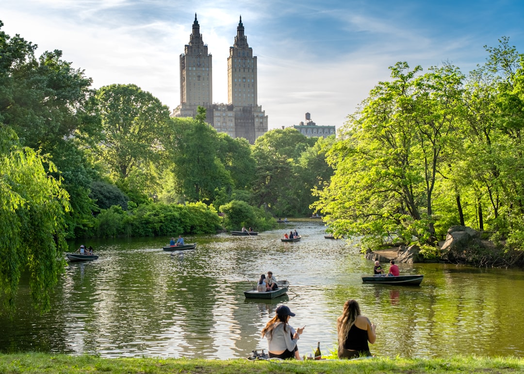
My favorite spot in NYC is Central Park, and there's nothing better than grabbing an excellent sando (and other fare) and enjoying a picnic.
Skip the hot dog carts and grab something from one of these spots. Set up on The Great Lawn or Sheep Meadow and enjoy!
Be sure to SAVE this guide in your Thatch library for your upcoming trip!
Foodie
Free
63
Northland is the northernmost of NZ's 16 regions. Come and immerse yourself in the pure beauty of New Zealand's sub-tropical paradise.
Explore Maori culture, the world's largest Kauri tree, pristine beaches, lush meadows boasting a striking shade of green found nowhere else and the Bay of Islands awaiting you with secluded beaches, dolphins and whales.
The Winterless North is a treasure trove of hidden gems and off the beaten path places, where countless rainbows await.
My guide includes 104 locations shown on an interactive map, the most beautiful places to visit, off the beaten path and hidden gem spots. The main focus of my guide is on outdoor nature places but also provides accommodation recommendations including free camps, places to eat and what to do.
I've visited all of these places myself (except some hotels and restaurants) during the more than 2 years that I lived in NZ. If you have time and you're doing a roadtrip you can just follow the route or simply pick out the places you like most.
50+ • Backpacker • Couples • Family • Groups • Female Solo • Vegetarian • Vegan • Adventure • Boutique • Budget • Camping • Foodie • Outdoors • People & Culture • Relaxation • Road Trip • Van Life • RV • Slow Travel • Romantic • Sustainable/Eco
$24.00
$30.00
20% off
9
Seven-day trek based in refugios.
INTRODUCTION
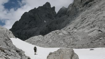
The Picos de Europa is a region of limestone peaks reaching over 2500 metres above sea level; the highest being Torre de Cerredo at 2650 metres. The route described here is one that I hiked alone in early summer. The best time to tackle the route is between June and September. There is more likely to be snow on the high passes in early June but they are usually not to difficult to negotiate.
The Picos de Europa is not as well known as the Pyrenees or Alps and as such the hiker traffic is less and the tourist infrastructure is less developed. This makes the area feel less spoilt but it can also make it a more challenging area to explore with fewer trails and little to no signposting. Always take a map with you: the Editorial Alpina 1:25,000 maps are the best. I took these and also used the outdooractive app and downloaded the relevant map tiles. This is useful for pinpointing where you are, in what can be confusing terrain. I was lucky to have clear weather for my entire trek but I would imagine that it's pretty difficult to navigate when the cloud is down on the mountains so take a compass too.
You can stay in refugios every night on this hike and wild camping is permitted above 1500m; details below.
I can't recommend the Picos de Europa as a hiking destination enough. The mountains are magnificent but there are also beautiful extensive woodlands at lower altitudes, as well as meadows full of wildflowers and butterflies. The juxtaposition between the stark limestone peaks and the gentle greenery of the valleys is beguiling.
DISCLAIMER: Please note that hiking in the Picos de Europa is not risk free. It is a very challenging area in which to hike. I accept no responsibility for any accidents you may experience while hiking this route. You are responsible for your own safety. Some of the dangers and difficulties are listed a little further down this guide.
HOW BUSY?
Unlike some of the more well know hikes around Europe this trail is less well trodden and as such the trail can be quite hard to follow at times, and at other times there is no trail! Despite this, refugios, being small, fill up fast (see below).
REFUGIOS
The hike is made easier if you stay in the staffed refugios where you can recharge your metaphorical batteries. Accommodation at these mountain huts is in communal dormitories and you will need to bring your own sleeping bag. It's best to book ahead as they are often full throughout the summer. Prices are around the €12-17 mark and they also do affordable meals (breakfast, picnic lunch and dinner).
There is also a handful of unstaffed, very basic mountain shelters with no services and no beds but these can be a good option in an emergency. Most of the refugios only accept cash so be sure to take plenty with you before you set off as there are no ATMs! All the refugios on the route are listed in the route description below with website links.
WILD CAMPING
Camping is only permitted at 1500m above sea level or higher. There is not much water anywhere above this altitude so be sure to fill up when you get the chance (at refugios) before camping in a remote spot.
POSADA DE VALDEON
This beautiful village tucked in the valley between the Macizo Central and Macizo Occidental is a lovely place to wander for a few hours. At the centre of the village there are a number of restaurants and bars and a small square with a water fountain. If you need somewhere to stay before or after the trek you'll find hotels, guest houses and a youth hostel. There is a hotel recommendation and link in the route description.
In the centre of the village is a pharmacy should you need any blister plasters! And on the road to the west of the village is the National Park office where you can find information about hiking and anything else to do with the national park.
GETTING THERE
From the UK there are Ryanair flights to Oviedo (Asturias airport) from London Stansted. A bit further afield you can get flights to Bilbao and Santander from the UK and the rest of Europe. Getting from the airport is a little complicated but there are buses to Posada de Valdeón from Oviedo changing in Cangas de Onis. The journey takes about 4.5hrs. There are also buses from Santander and Bilbao changing in Llanes and Riaño with the journey taking around 15hrs from Bilbao.
An easier but more expensive option is to get a taxi. You could also hire a car but of course you will have to leave the car sitting idle in Posada de Valdeón while you do the hike.
FLORA & FAUNA
This area of northern Spain is fantastic for wildlife. At lower elevations the beech and sessile oak woodland stretches for miles over rolling hills. This is part of the boreal forest that once would have covered much of Europe and is home to roe deer, wild boar, red squirrels, pine martens and brown bears.
In the skies you have a good chance of seeing griffon vultures, golden, booted and short-toed eagles, black kites and peregrines. Of the smaller passerine species the Picos are home to red-backed shrikes, black redstarts, spotted flycatchers and black woodpeckers.
But it's the wildflowers in the meadows and on the woodland edges that are the real joy and most easily appreciated. Vetches, cinquefoils and orchids create a colourful patchwork of colours with butterflies bringing the whole scene to life. Look out for swallowtails, fritillaries and hairstreaks.
NAVIGATION
Navigation is difficult as the terrain can be confusing and in many places there is no trail whatsoever. Take a map (1:25K Editiorial Alpina maps are the best), compass and GPS and know how to use them. It's also a good idea to download the map on a relevant map app. I used the outdooractive app but others are available.
WEATHER
Thunderstorms are common, usually in the afternoon and these can be particularly dangerous high up in the mountains. It's best to hike early and get to a refugio by lunchtime if there are afternoon thunderstorms in the forecast. The weather in this part of Spain is very changeable as it has a maritime climate. Rain and thick fog are possible but equally long periods of warm sunshine are not unusual. The best advice I can offer is to be prepared for anything. Pack suncream and a sunhat but don't forget your waterproofs either.
FALLING ROCKS
Rock falls are not unusual as chamois and other hikers can dislodge rocks above you. Getting caught in a rockfall is not so common but not impossible. Be aware and if you see rocks heading your way, and cannot find cover, crouch down on the floor and pull your rucksack over your head and back.
DRINKING WATER
There is very little running water as these mountains are mostly comprised of permeable limestone. You will need to take plenty of water with you each day (I packed three litres every day and usually drank it all). You can fill up at the refugios and there are a few fountains / fuentes although most of the ones I saw marked on the Editorial Alpina map were dry when I found them.
THE SUN
Sunburn and sunstroke are both real dangers and there is little shade. Keep hydrated and wear a sun hat that covers your neck.
TERRAIN
In some places you need to scramble up steep rocky sections. You will need to have experience in this kind of terrain and have a head for heights! The terrain is very rocky and uneven at higher altitudes so you will need strong, sturdy footwear. Trekking poles are also invaluable in providing support and helping you across and up awkward sections. There is also a lot of steep ascent and descent on this route so you will need to be reasonably fit.
DANGEROUS ANIMALS
On many parts of the trail you will encounter cows. In my experience they are very docile and used to trekkers so they shouldn't be of any concern. You may also find flocks of sheep and while these aren't dangerous they are often accompanied by shepherd dogs which have been trained to keep intruders away from the flock. They can be quite intimidating when they start barking at you. If you see sheep ahead it is best to give them a wide berth, even if this means veering away from the trail for a while. If you walk directly towards or through a flock of sheep you risk agitating the shepherd dogs.
Bears are not common in the Picos de Europa but there are bears in other parts of the Cantabrian Mountains, notably Somiedo National Park, not far to the west, and there is always the possibility of seeing an itinerant bear wandering through the Picos. Eurasian brown bears are not as big nor aggressive as the grizzly bears of North America so you shouldn't worry too much about an encounter. It's extremely unlikely you will see one so if you do, consider yourself very lucky.
Wild boar are common in the woodlands at lower altitudes. They are not as aggressive as some people will tell you and tend to be nocturnal. I did see some in the daytime near Vegabaño. As soon as they saw me they ran away, crashing through the undergrowth. As with any large animal it's best to simply give them plenty of space to move away from you.
I hope none of this advice puts you off hiking in the Picos de Europa. Yes, it's a challenging mountain area but the rewards for hiking here are great. Enjoy the hike!
Adventure • Nature • Slow Travel • Sustainable/Eco • Mountain • Camping
$12.00
3
Lassen Volcanic National Park is one of California's more underrated national parks. Lassen is home to spectacular hydrothermal features, stunning mountain lakes, wildflower filled meadows, and of course volcanos. Located in northeastern California at the crossroads of the Cascade and Sierra Nevada Mountain Ranges, Lassen is subject to high snowfall in the winter, making late spring through early fall the best time of year to visit.
This map highlights the best stops along Lassen Volcanic National Park Highway, the main road through the park, from South to North. The entire route is about 30 miles, and without stopping the entire route takes about an hour to complete.
Also included are a few stops at the Butte Lake entrance, however to get here you must drive along 6 miles of unpaved road.
This map also details some of the best and more popular hikes in Lassen.
$5.00
2

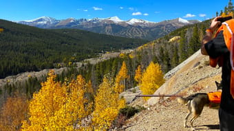
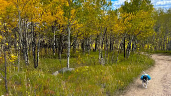
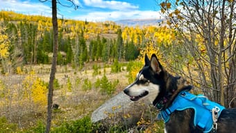
Autumn in Colorado is all about hunting those vibrant golden sparkles of Aspen leaves that cover the mountain meadows and hillsides. This guide gives you everything you need for a magical weekend getaway in/around Breckenridge, Co, filled with stunning scenery, crisp fall air, and some of the most luscious spots for viewing fall colors.
Expect colors to peak in Breckenridge Sept 15-Oct 5 (ish), but you will still catch some magic if you visit up to a week outside these days.
EMAIL me for a discount code! pupperscouts@gmail.com
Breckenridge, Colorado, is a small former mining community turned world class ski destination. The downtown is adorable and walkable, filled with restaurants, shops, and scenic views galore. Visiting during fall means all the fun with smaller crowds than winter.
Inside you'll find suggested itineraries for two days of fun, that include:
-Lodging options
-Restaurant options with fall-forward vibes (think Oktoberfest beers, seasonal menus, smokey flavors, & scenic views)
-Best hikes for viewing foliage, all in the easy-moderate range of difficulty
-Suggestions for scenic leaf-peeping drives
-Suggestions for epic sunset-viewing spots
The best part is that ALL of these spots are vetted and dog-friendly, meaning you never have to make arrangements for leaving your doggo behind if you don't want to.
This is a living guide, and will be updated as more information is learned. This is a living guide. As I discover more, I'll add more. You only have to unlock it once, and you'll get all future updates.
Families • LGBTQ+ • Digital Nomads • Plus Size • Vegetarian • Solo Female • Gluten-free / Celiac • Pets • 50+ • Couples • Groups • Adventure • Art • Boutique • Foodie • Wellness • History • Shopping • Nature • RV • Romantic • Photography • Van Life • Road Trip • Coffee • Mountain • Camping • Relaxation
$4.50
$5.00
10% off
1
Autumn in Colorado is all about hunting those vibrant golden sparkles of Aspen leaves that cover the mountain meadows and hillsides. This guide gives you everything you need for a magical weekend getaway in/around Georgetown, Co, filled with stunning scenery, crisp fall air, and some of the most luscious spots for viewing fall colors.
EMAIL me for a 15% discount code! pupperscouts@gmail.com
Georgetown is the gateway to Guanella Pass, a stunning scenic drive that takes you right through a series of epic peaks. The town itself is quaint and historic, with a small walkable downtown and beautiful views. Located just 45 min. drive from Downtown Denver, this area is such a gem. It's often passed by for trips a little further into the mountains, we highly recommend a stop!
Inside you'll find suggested itineraries for two days of fun, that include:
-Lodging options
-Restaurant options with fall-forward vibes (ALL include gluten free & vegetarian options)
-Best hikes for viewing foliage, all in the easy-moderate range of difficulty
-Suggestions for scenic leaf-peeping drives
-Suggestions for epic sunset-viewing spots
The best part is that ALL of these spots are vetted and dog-friendly, meaning you never have to make arrangements for leaving your doggo behind if you don't want to.
This is a living guide, and will be updated as more information is learned. This is a living guide. As I discover more, I'll add more. You only have to unlock it once, and you'll get all future updates.
Families • LGBTQ+ • Digital Nomads • Plus Size • Vegetarian • Solo Female • Gluten-free / Celiac • Pets • 50+ • Couples • Groups • Adventure • Budget • Wellness • History • Nature • RV • Romantic • Photography • Van Life • Road Trip • Coffee • Mountain • Relaxation
$4.50
$5.00
10% off
0
Autumn in Colorado is all about hunting those vibrant golden sparkles of Aspen leaves that cover the mountain meadows and hillsides. This guide gives you everything you need for a magical weekend getaway in/around Silverthorne & Dillon, Co, in Summit County, filled with stunning scenery, crisp fall air, and some of the most luscious spots for viewing fall colors.
Expect colors to peak in Silverthorne & Dillon Sept 15-Oct 5 (ish), but you will still catch some magic if you visit up to a week outside these days.
EMAIL me for a discount code! pupperscouts@gmail.com
Silverthorne & Dillon are small adjascent towns located on the banks of the drop dead gorgeous Dillon Reservior. These towns serve as the gateway to Summit County's world class ski areas. Visiting during fall means all the fun, plus smaller crowds than winter. Just an 1 hr 15 min drive from Denver, this area really has it all!
Inside you'll find suggested itineraries for two days of fun, that include:
-Lodging options
-Restaurant options with fall-forward vibes (ALL have both Gluten Free and Vegetarian options)
-Best hikes for viewing foliage, all in the easy-moderate range of difficulty
-Suggestions for scenic leaf-peeping drives
-Suggestions for epic sunset-viewing spots
The best part is that ALL of these spots are vetted and dog-friendly, meaning you never have to make arrangements for leaving your doggo behind if you don't want to.
This is a living guide, and will be updated as more information is learned. This is a living guide. As I discover more, I'll add more. You only have to unlock it once, and you'll get all future updates.
Families • LGBTQ+ • Digital Nomads • Plus Size • Vegetarian • Gluten-free / Celiac • Pets • 50+ • Couples • Groups • Adventure • Boutique • Budget • Foodie • Wellness • Shopping • Nature • RV • Romantic • Photography • Van Life • Road Trip • Coffee • Mountain • Camping • Relaxation
$4.50
$5.00
10% off
0
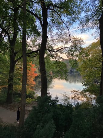
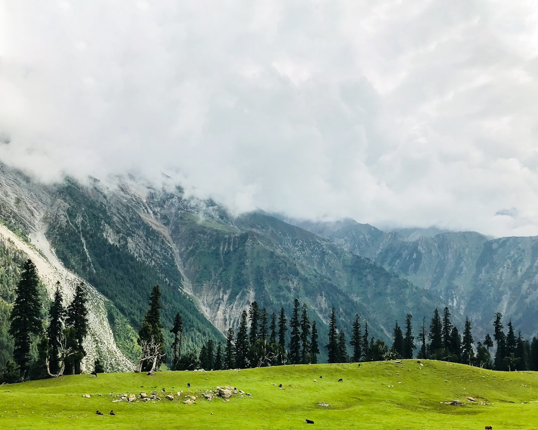
🌳 New York’s largest urban park, spanning 843 acres is a lush oasis in the heart of Manhattan. It boasts historic landmarks, artificial lakes, waterfalls, meadows, and wooded areas.
Follow me on one of my favorite strolls through the southeastern corner of the park—from the Wien Walk to the iconic Boathouse. It’s a fun, densely packed, 30-minute walk covering 1.2 miles. Breezy!
50+ • Car-free • Couples • Family • Groups • Female Solo • Adventure • Architecture • Budget • Coffee • History • Outdoors • Relaxation • People & Culture • Photography • Slow Travel
Free
0
Planning a trip to Kashmir? Get ready to be mesmerized by the paradise on earth! Kashmir is a feast to your eyes and hearts in all seasons- lined up with green meadows and blossoming gardens in summer and snow-capped mountains in winter.
This FREE 6-day itinerary for Kashmir is comprehensive and is guided by our own trips to this magical place. The guide includes:
Detailed outlines of what you should do in each of the 6 days
Recommendations of places, stays, and restaurants that we have personally tried
Pro tips for your trip guided by our experience
Couples • Family • Outdoors • Photography • Romantic
Free
2
The Wonderland Trail is an epic 150-kilometer (93-mile) loop that encircles Mount Rainier, offering a diverse and rewarding experience perfect for hikers of all skill levels. With an elevation gain of over 7,000 meters (23,000 feet), this trail provides stunning vistas, alpine meadows, glacier views, and serene old growth forest paths, making it a journey of breathtaking beauty. Designed for flexibility, the trail has numerous trailheads and resupply options, making it ideal for both beginners and seasoned trekkers. While the recommended time to complete the Wonderland Trail is 7-12 days, the trail can be adapted to suit different timeframes and difficulty preferences. Key highlights include Klapatche Lake, Indian Bar, Panhandle Gap, Summerland, Spray Park, and Sunrise - each offering its own unique scenery and unforgettable experiences.
What this guide includes:
- A flexible itinerary for different lengths and difficulty levels;
- Detailed information on distances, the best overnight camping options, how to obtain permits, how to resupply, and other useful waypoints;
- Custom Google Maps featuring important locations like campsites, grocery stores, trails, and viewpoints;
- Downloadable GPX-tracks of all the routes for GPS navigation;
- Practical information on how to get there, how to navigate the trail, the best time to go, trail conditions, weather, and geography;
- Comprehensive route descriptions that detail landmarks, terrain, and elevation changes.
This guide will provide you with everything you need to plan and complete your hike on the Wonderland Trail, ensuring you have an unforgettable adventure in the heart of the Pacific Northwest.
Get an impression of this route on YouTube.com/HarmenHoek
Backpacker • Groups • Car-free • Female Solo • Family • Adventure • Camping • Budget • Outdoors • Photography • Relaxation • Sustainable/Eco • Slow Travel
$15.00
1

This classic American Scenic Drive is 106 miles of stunning natural beauty, featuring the Blue Ridge Mountains, national parks, forests, historic sites, hiking trails, and more. Along the way, there are several great camping spots, making this the perfect trip to do with your Luno gear.
Couples • Groups • Adventure • Nature • Camping • Roadtrip • Mountain • Relaxation • Foodie
Free
6

This comprehensive guide includes essential information, the best hikes, views, eats, and more in Yosemite National Park, California:
✅ Essential info: how to get to Yosemite, transport, entry fees & reservations, when to visit, & how long to visit.
✅ 15 top hikes
✅ 20 top views
✅ Where to stay
✅ Where to camp
✅ What to eat
✅ Current weather
✅ Seasonal recommendations & tips
✅ Other resources
✅ Interactive map
✅ Mobile-friendly
More questions or need more information? DM @roamfreerebecca or email becca@roamfreerebecca.com for an even more customized guide and tips!
Accessibility • Nature • Adventure • Hiking • Views • Camping • Foodie • Seasonal Recommendations • Travel Tips
$20.00
12


There are so many amazing national parks within driving distance in this area. We have had a lot of people ask us to share our itinerary for this specific trip. So, here is our version of the BEST itinerary for a road trip through the American Southwest.
We took this trip at the end of May into the first week of June. We actually did the trip in the reverse direction that I am going to list here, but you get to learn from our experience. If you travel in late spring or early summer, we feel that the direction below is the best direction. If you travel in late summer or early fall, you would want to reverse the direction.
Families • Couples • Backpackers • Adventure • Budget • Nature • Road Trip • Mountain
$10.00
4
This map gives you an overview of places you can visit for free in and around Orlando
Divided into: Attractions and Entertainment, Nature Reserves/Parks and Local Markets
50+ • Accessibility • Car-free • Couples • Digital Nomads • Family • Gluten-free / Celiac • Groups • Halal • LGBTQ+ • Pets • Plus Size • Female Solo • Vegan • Vegetarian • Adventure • Boutique • Camping • Budget • History • Outdoors • Overlanding • People & Culture • Photography • Relaxation • Road Trip • Romantic • Slow Travel • Sustainable/Eco • Van Life
Free
1


Try ThatchGPT