Picos de Europa - 7 day hiking guide
Save for Later
Share
Picos de Europa - 7 day hiking guide
Jim Manthorpe
Seven-day trek based in refugios.
INTRODUCTION
The Picos de Europa is a region of limestone peaks reaching over 2500 metres above sea level; the highest being Torre de Cerredo at 2650 metres. The route described here is one that I hiked alone in early summer. The best time to tackle the route is between June and September. There is more likely to be snow on the high passes in early June but they are usually not to difficult to negotiate.
The Picos de Europa is not as well known as the Pyrenees or Alps and as such the hiker traffic is less and the tourist infrastructure is less developed. This makes the area feel less spoilt but it can also make it a more challenging area to explore with fewer trails and little to no signposting. Always take a map with you: the Editorial Alpina 1:25,000 maps are the best. I took these and also used the outdooractive app and downloaded the relevant map tiles. This is useful for pinpointing where you are, in what can be confusing terrain. I was lucky to have clear weather for my entire trek but I would imagine that it's pretty difficult to navigate when the cloud is down on the mountains so take a compass too.
You can stay in refugios every night on this hike and wild camping is permitted above 1500m; details below.
I can't recommend the Picos de Europa as a hiking destination enough. The mountains are magnificent but there are also beautiful extensive woodlands at lower altitudes, as well as meadows full of wildflowers and butterflies. The juxtaposition between the stark limestone peaks and the gentle greenery of the valleys is beguiling.
DISCLAIMER: Please note that hiking in the Picos de Europa is not risk free. It is a very challenging area in which to hike. I accept no responsibility for any accidents you may experience while hiking this route. You are responsible for your own safety. Some of the dangers and difficulties are listed a little further down this guide.
HOW BUSY?
Unlike some of the more well know hikes around Europe this trail is less well trodden and as such the trail can be quite hard to follow at times, and at other times there is no trail! Despite this, refugios, being small, fill up fast (see below).
REFUGIOS
The hike is made easier if you stay in the staffed refugios where you can recharge your metaphorical batteries. Accommodation at these mountain huts is in communal dormitories and you will need to bring your own sleeping bag. It's best to book ahead as they are often full throughout the summer. Prices are around the €12-17 mark and they also do affordable meals (breakfast, picnic lunch and dinner).
There is also a handful of unstaffed, very basic mountain shelters with no services and no beds but these can be a good option in an emergency. Most of the refugios only accept cash so be sure to take plenty with you before you set off as there are no ATMs! All the refugios on the route are listed in the route description below with website links.
WILD CAMPING
Camping is only permitted at 1500m above sea level or higher. There is not much water anywhere above this altitude so be sure to fill up when you get the chance (at refugios) before camping in a remote spot.
POSADA DE VALDEON
This beautiful village tucked in the valley between the Macizo Central and Macizo Occidental is a lovely place to wander for a few hours. At the centre of the village there are a number of restaurants and bars and a small square with a water fountain. If you need somewhere to stay before or after the trek you'll find hotels, guest houses and a youth hostel. There is a hotel recommendation and link in the route description.
In the centre of the village is a pharmacy should you need any blister plasters! And on the road to the west of the village is the National Park office where you can find information about hiking and anything else to do with the national park.
GETTING THERE
From the UK there are Ryanair flights to Oviedo (Asturias airport) from London Stansted. A bit further afield you can get flights to Bilbao and Santander from the UK and the rest of Europe. Getting from the airport is a little complicated but there are buses to Posada de Valdeón from Oviedo changing in Cangas de Onis. The journey takes about 4.5hrs. There are also buses from Santander and Bilbao changing in Llanes and Riaño with the journey taking around 15hrs from Bilbao.
An easier but more expensive option is to get a taxi. You could also hire a car but of course you will have to leave the car sitting idle in Posada de Valdeón while you do the hike.
FLORA & FAUNA
This area of northern Spain is fantastic for wildlife. At lower elevations the beech and sessile oak woodland stretches for miles over rolling hills. This is part of the boreal forest that once would have covered much of Europe and is home to roe deer, wild boar, red squirrels, pine martens and brown bears.
In the skies you have a good chance of seeing griffon vultures, golden, booted and short-toed eagles, black kites and peregrines. Of the smaller passerine species the Picos are home to red-backed shrikes, black redstarts, spotted flycatchers and black woodpeckers.
But it's the wildflowers in the meadows and on the woodland edges that are the real joy and most easily appreciated. Vetches, cinquefoils and orchids create a colourful patchwork of colours with butterflies bringing the whole scene to life. Look out for swallowtails, fritillaries and hairstreaks.
NAVIGATION
Navigation is difficult as the terrain can be confusing and in many places there is no trail whatsoever. Take a map (1:25K Editiorial Alpina maps are the best), compass and GPS and know how to use them. It's also a good idea to download the map on a relevant map app. I used the outdooractive app but others are available.
WEATHER
Thunderstorms are common, usually in the afternoon and these can be particularly dangerous high up in the mountains. It's best to hike early and get to a refugio by lunchtime if there are afternoon thunderstorms in the forecast. The weather in this part of Spain is very changeable as it has a maritime climate. Rain and thick fog are possible but equally long periods of warm sunshine are not unusual. The best advice I can offer is to be prepared for anything. Pack suncream and a sunhat but don't forget your waterproofs either.
FALLING ROCKS
Rock falls are not unusual as chamois and other hikers can dislodge rocks above you. Getting caught in a rockfall is not so common but not impossible. Be aware and if you see rocks heading your way, and cannot find cover, crouch down on the floor and pull your rucksack over your head and back.
DRINKING WATER
There is very little running water as these mountains are mostly comprised of permeable limestone. You will need to take plenty of water with you each day (I packed three litres every day and usually drank it all). You can fill up at the refugios and there are a few fountains / fuentes although most of the ones I saw marked on the Editorial Alpina map were dry when I found them.
THE SUN
Sunburn and sunstroke are both real dangers and there is little shade. Keep hydrated and wear a sun hat that covers your neck.
TERRAIN
In some places you need to scramble up steep rocky sections. You will need to have experience in this kind of terrain and have a head for heights! The terrain is very rocky and uneven at higher altitudes so you will need strong, sturdy footwear. Trekking poles are also invaluable in providing support and helping you across and up awkward sections. There is also a lot of steep ascent and descent on this route so you will need to be reasonably fit.
DANGEROUS ANIMALS
On many parts of the trail you will encounter cows. In my experience they are very docile and used to trekkers so they shouldn't be of any concern. You may also find flocks of sheep and while these aren't dangerous they are often accompanied by shepherd dogs which have been trained to keep intruders away from the flock. They can be quite intimidating when they start barking at you. If you see sheep ahead it is best to give them a wide berth, even if this means veering away from the trail for a while. If you walk directly towards or through a flock of sheep you risk agitating the shepherd dogs.
Bears are not common in the Picos de Europa but there are bears in other parts of the Cantabrian Mountains, notably Somiedo National Park, not far to the west, and there is always the possibility of seeing an itinerant bear wandering through the Picos. Eurasian brown bears are not as big nor aggressive as the grizzly bears of North America so you shouldn't worry too much about an encounter. It's extremely unlikely you will see one so if you do, consider yourself very lucky.
Wild boar are common in the woodlands at lower altitudes. They are not as aggressive as some people will tell you and tend to be nocturnal. I did see some in the daytime near Vegabaño. As soon as they saw me they ran away, crashing through the undergrowth. As with any large animal it's best to simply give them plenty of space to move away from you.
I hope none of this advice puts you off hiking in the Picos de Europa. Yes, it's a challenging mountain area but the rewards for hiking here are great. Enjoy the hike!
Updated ago
3
Share
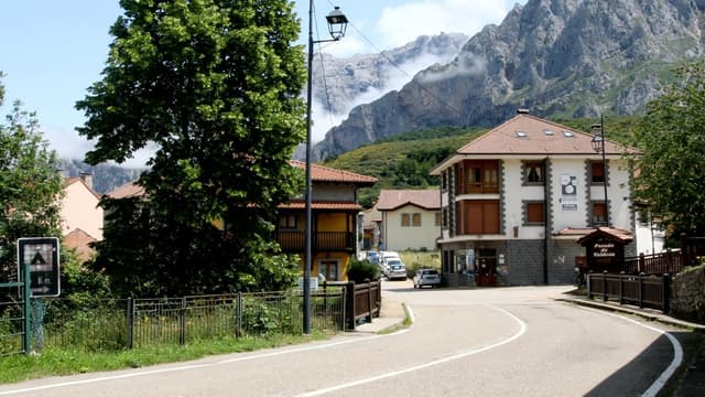
1 Posada de Valdeón - fountain in village square
@jimmanthorpe
Posada de Valdeón is a beautiful village tucked in the valley between the Macizo Central and Macizo Occidental of the Picos de Europa. Here you will find hotels, a youth hostel, bars and restaurants and a pharmacy and shop. Buses from Oviedo take about 3.5hrs.
To start the hike, head west along the main road and then cross over onto the north side of the Rio Cares to follow a quieter lane through woods and fields towards Soto de Valdeon.
Add to
Details
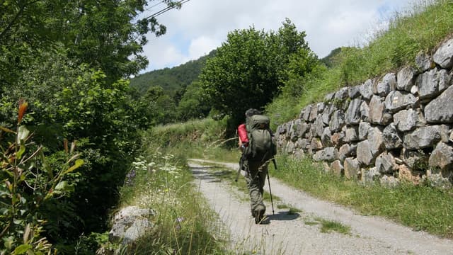
2 Soto de Valdeón
@jimmanthorpe
Head through this sleepy village. No facilities here and not much to see but there are plenty of beautiful wild flowers in the hedgerows and lots of butterflies.
Add to
Details
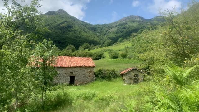
3 Majada de Argolla - basic stone shelter
@jimmanthorpe
There are two old shepherd's huts here. The larger one is locked but the smaller one is left open and is just big enough to sleep in. This is not the Ritz and really only works as a rough emergency shelter or somewhere to stop and have a sandwich when it's raining.
Add to
Details
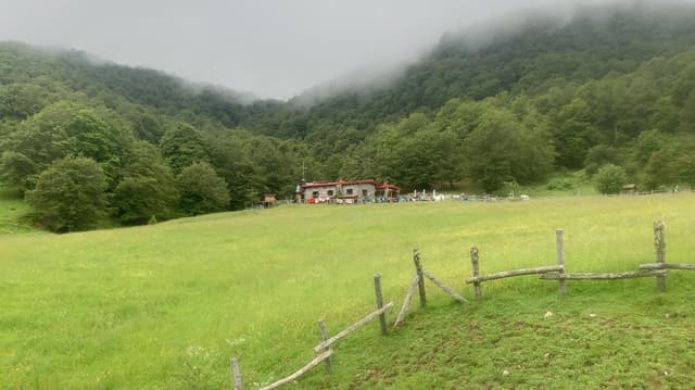
6 Refugio Vegabaño
@jimmanthorpe
35 beds, breakfast, picnic and dinner. Booking advised. This lovely refugio sits beside a large paddock and among beautiful beech woodland. Even if you don't stay the night there are some picnic benches outside where you can enjoy a cool drink or a snack as I did.
Add to
Details
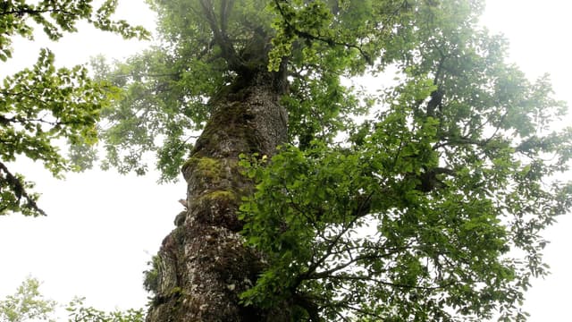
7 Roblon de Cuesta Fria - ancient oak tree
@jimmanthorpe
This huge ancient oak tree (roble is Spanish for oak - roblon is Spanish for big oak!) with a circumference of seven metres is the oldest tree in the forest. A wooden fence has been put up around it to protect it. You could easily hop over the fence but it would be a good idea to respect the tree and admire it from a distance.
Add to
Details

Add to
Details
9 Refugio del Frade
@jimmanthorpe
Don't expect much luxury here. If you are familiar with Scottish bothies, this is a Spanish equivalent - an unlocked stone hut with no frills. There's a fireplace but there was no wood when I stayed here. You can lay your sleeping bag across the wide bench or on the dusty floor. Beware of the mice! Hang your food in a bag from the ceiling and it should be fine.
Add to
Details

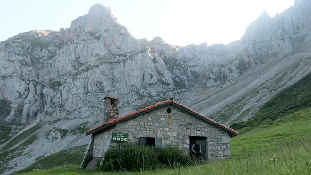
10 Refugio Vega Huerta
@jimmanthorpe
Another the very basic hut with room for only four people so it doesn't take much for it to be full to capacity. Be prepared to camp if there is no room. It's a spectacular spot among high limestone peaks.
Add to
Details

Buy to unlock full guide
Access all the local insights and recommendations from @jimmanthorpe when you purchase this guide.
ABOUT THE AUTHOR
Jim Manthorpe
I have worked as an adventure travel guide author for over 20 years, writing and updating Trailblazer guidebooks to hiking in the Himalayas, the Alps and Scotland. I am also a wildlife cameraman and have helped create sequences for landmark natural history series for the BBC and NatGeo including the latest David Attenborough series Wild Isles.
What's included
Digital Map
Fully interactive, digital map for finding places nearby
71 places
71 hand-picked places with notes from the creator
DESTINATION(S) COVERED
Asturias, Spain
Picos de Europa National Park, Oviedo, Spain
León, Spain
Picos de Europa, Spain
Cantabria, Spain
Spain
FOCUSES AND THEMES
Adventure
Nature
Slow Travel
Sustainable/Eco
Mountain
Camping
BEST TIME OF YEAR
JAN
FEB
MAR
APR
MAY
JUN
JUL
AUG
SEP
OCT
NOV
DEC
Format
Itinerary
Itineraries typically include day-by-day plans, with food, lodging and activity recommendations for each day.
COMMON QUESTIONS
What is Thatch?
Thatch is an online marketplace that provides instant access to thousands of vetted local experts and premium travel guides - making it the easiest and most affordable way to take high quality trips with less stress.
For travel creators (tastemakers, travel advisors, influencers and local experts) Thatch makes it easy to curate, publish, and sell digital travel guides, itineraries and personalized planning services.
What if I’m not satisfied with my purchase?
How do I access my purchased guides?
Can I access my guide offline?
How often are guides updated?
Can I request a personalized guide or itinerary?
Can I sell my own travel guides and itineraries?
Save for Later
Share