Results for People
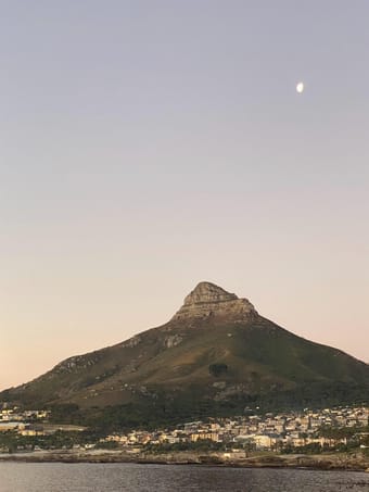
This is a hassle free, easy going guide to follow if you only have 2 days to explore the city of Cape Town. This guide is perfect for people who want to see what the city has to offer but also don't want an itinerary that is too busy. With this guide will be focused on the city centre and surrounding areas like Sea Point.
Couples • Female Solo • Relaxation • Outdoors • Foodie • Coffee • Adventure
Free
4
Hostels offer a combination of affordability, social atmosphere, cultural exchange, and convenience that makes them an appealing choice for many travelers, particularly those seeking a vibrant and immersive travel experience. Compared to hotels or other types of accommodations, hostels typically offer lower prices, especially for dormitory-style rooms where multiple travelers share a room. Hostels typically include common areas such as lounges, kitchens, and communal spaces provide opportunities to meet people from different backgrounds, share experiences, and make new friends.
Backpackers • Solo Female • Adventure
Free
4

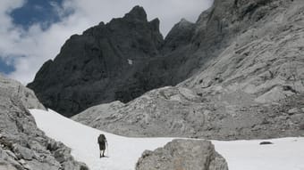
Seven-day trek based in refugios.
INTRODUCTION
The Picos de Europa is a region of limestone peaks reaching over 2500 metres above sea level; the highest being Torre de Cerredo at 2650 metres. The route described here is one that I hiked alone in early summer. The best time to tackle the route is between June and September. There is more likely to be snow on the high passes in early June but they are usually not to difficult to negotiate.
The Picos de Europa is not as well known as the Pyrenees or Alps and as such the hiker traffic is less and the tourist infrastructure is less developed. This makes the area feel less spoilt but it can also make it a more challenging area to explore with fewer trails and little to no signposting. Always take a map with you: the Editorial Alpina 1:25,000 maps are the best. I took these and also used the outdooractive app and downloaded the relevant map tiles. This is useful for pinpointing where you are, in what can be confusing terrain. I was lucky to have clear weather for my entire trek but I would imagine that it's pretty difficult to navigate when the cloud is down on the mountains so take a compass too.
You can stay in refugios every night on this hike and wild camping is permitted above 1500m; details below.
I can't recommend the Picos de Europa as a hiking destination enough. The mountains are magnificent but there are also beautiful extensive woodlands at lower altitudes, as well as meadows full of wildflowers and butterflies. The juxtaposition between the stark limestone peaks and the gentle greenery of the valleys is beguiling.
DISCLAIMER: Please note that hiking in the Picos de Europa is not risk free. It is a very challenging area in which to hike. I accept no responsibility for any accidents you may experience while hiking this route. You are responsible for your own safety. Some of the dangers and difficulties are listed a little further down this guide.
HOW BUSY?
Unlike some of the more well know hikes around Europe this trail is less well trodden and as such the trail can be quite hard to follow at times, and at other times there is no trail! Despite this, refugios, being small, fill up fast (see below).
REFUGIOS
The hike is made easier if you stay in the staffed refugios where you can recharge your metaphorical batteries. Accommodation at these mountain huts is in communal dormitories and you will need to bring your own sleeping bag. It's best to book ahead as they are often full throughout the summer. Prices are around the €12-17 mark and they also do affordable meals (breakfast, picnic lunch and dinner).
There is also a handful of unstaffed, very basic mountain shelters with no services and no beds but these can be a good option in an emergency. Most of the refugios only accept cash so be sure to take plenty with you before you set off as there are no ATMs! All the refugios on the route are listed in the route description below with website links.
WILD CAMPING
Camping is only permitted at 1500m above sea level or higher. There is not much water anywhere above this altitude so be sure to fill up when you get the chance (at refugios) before camping in a remote spot.
POSADA DE VALDEON
This beautiful village tucked in the valley between the Macizo Central and Macizo Occidental is a lovely place to wander for a few hours. At the centre of the village there are a number of restaurants and bars and a small square with a water fountain. If you need somewhere to stay before or after the trek you'll find hotels, guest houses and a youth hostel. There is a hotel recommendation and link in the route description.
In the centre of the village is a pharmacy should you need any blister plasters! And on the road to the west of the village is the National Park office where you can find information about hiking and anything else to do with the national park.
GETTING THERE
From the UK there are Ryanair flights to Oviedo (Asturias airport) from London Stansted. A bit further afield you can get flights to Bilbao and Santander from the UK and the rest of Europe. Getting from the airport is a little complicated but there are buses to Posada de Valdeón from Oviedo changing in Cangas de Onis. The journey takes about 4.5hrs. There are also buses from Santander and Bilbao changing in Llanes and Riaño with the journey taking around 15hrs from Bilbao.
An easier but more expensive option is to get a taxi. You could also hire a car but of course you will have to leave the car sitting idle in Posada de Valdeón while you do the hike.
FLORA & FAUNA
This area of northern Spain is fantastic for wildlife. At lower elevations the beech and sessile oak woodland stretches for miles over rolling hills. This is part of the boreal forest that once would have covered much of Europe and is home to roe deer, wild boar, red squirrels, pine martens and brown bears.
In the skies you have a good chance of seeing griffon vultures, golden, booted and short-toed eagles, black kites and peregrines. Of the smaller passerine species the Picos are home to red-backed shrikes, black redstarts, spotted flycatchers and black woodpeckers.
But it's the wildflowers in the meadows and on the woodland edges that are the real joy and most easily appreciated. Vetches, cinquefoils and orchids create a colourful patchwork of colours with butterflies bringing the whole scene to life. Look out for swallowtails, fritillaries and hairstreaks.
NAVIGATION
Navigation is difficult as the terrain can be confusing and in many places there is no trail whatsoever. Take a map (1:25K Editiorial Alpina maps are the best), compass and GPS and know how to use them. It's also a good idea to download the map on a relevant map app. I used the outdooractive app but others are available.
WEATHER
Thunderstorms are common, usually in the afternoon and these can be particularly dangerous high up in the mountains. It's best to hike early and get to a refugio by lunchtime if there are afternoon thunderstorms in the forecast. The weather in this part of Spain is very changeable as it has a maritime climate. Rain and thick fog are possible but equally long periods of warm sunshine are not unusual. The best advice I can offer is to be prepared for anything. Pack suncream and a sunhat but don't forget your waterproofs either.
FALLING ROCKS
Rock falls are not unusual as chamois and other hikers can dislodge rocks above you. Getting caught in a rockfall is not so common but not impossible. Be aware and if you see rocks heading your way, and cannot find cover, crouch down on the floor and pull your rucksack over your head and back.
DRINKING WATER
There is very little running water as these mountains are mostly comprised of permeable limestone. You will need to take plenty of water with you each day (I packed three litres every day and usually drank it all). You can fill up at the refugios and there are a few fountains / fuentes although most of the ones I saw marked on the Editorial Alpina map were dry when I found them.
THE SUN
Sunburn and sunstroke are both real dangers and there is little shade. Keep hydrated and wear a sun hat that covers your neck.
TERRAIN
In some places you need to scramble up steep rocky sections. You will need to have experience in this kind of terrain and have a head for heights! The terrain is very rocky and uneven at higher altitudes so you will need strong, sturdy footwear. Trekking poles are also invaluable in providing support and helping you across and up awkward sections. There is also a lot of steep ascent and descent on this route so you will need to be reasonably fit.
DANGEROUS ANIMALS
On many parts of the trail you will encounter cows. In my experience they are very docile and used to trekkers so they shouldn't be of any concern. You may also find flocks of sheep and while these aren't dangerous they are often accompanied by shepherd dogs which have been trained to keep intruders away from the flock. They can be quite intimidating when they start barking at you. If you see sheep ahead it is best to give them a wide berth, even if this means veering away from the trail for a while. If you walk directly towards or through a flock of sheep you risk agitating the shepherd dogs.
Bears are not common in the Picos de Europa but there are bears in other parts of the Cantabrian Mountains, notably Somiedo National Park, not far to the west, and there is always the possibility of seeing an itinerant bear wandering through the Picos. Eurasian brown bears are not as big nor aggressive as the grizzly bears of North America so you shouldn't worry too much about an encounter. It's extremely unlikely you will see one so if you do, consider yourself very lucky.
Wild boar are common in the woodlands at lower altitudes. They are not as aggressive as some people will tell you and tend to be nocturnal. I did see some in the daytime near Vegabaño. As soon as they saw me they ran away, crashing through the undergrowth. As with any large animal it's best to simply give them plenty of space to move away from you.
I hope none of this advice puts you off hiking in the Picos de Europa. Yes, it's a challenging mountain area but the rewards for hiking here are great. Enjoy the hike!
Adventure • Nature • Slow Travel • Sustainable/Eco • Mountain • Camping
$12.00
3
I want to help you discover the lesser known places in Florence. You already know the David, the Duomo, and Ponte Vecchio. But do you know the best place to get a craft beer? Eat the best Chinese food? Join a summer beach party? I’m here to help you live like a local!
I spent two years living in the beautiful Renaissance city of Florence, Italy. Spending so much time in this city allowed me to remove myself from the regular touristy spots that so many people get caught up going to when they have just a few days here.
Unfortunately, Florence really does suffer from over-tourism, particularly in the summer months. This can make it difficult to feel like you're truly a part of the life of the city. Fortunately, however, there are a ton of great places around the city, less known to tourists, where you can get to know another part of the city.
In this guide, I will introduce you to those spots: the lesser-known, more local hot spots to have coffee, eat breakfast, lunch, dinner, date night, live music, and drink the night away.
This guide is perfect for people who want to go to hip and cool places that are off the beaten path, which can be hard to find in Florence. Maybe you're going to be in Florence for just a few days and want to be in the know right away, or maybe you're a student coming to spend a semester in Florence. This guide will help you get a head start on all the best places that your friends probably haven't told you about.
I've also provided information about transportation around the city, from walking to biking to the tramvia, etc.
What this guide does NOT include: All of the historical sites, art museums, and famous statues. Every blog post includes these types of things in Florence. I want to provide you with another side of Florence.
50+ • Backpacker • Car-free • Couples • Digital Nomads • Family • Groups • LGBTQ+ • Female Solo • Foodie • People & Culture
$14.99
3

Lauren Alboini
Available for hire
Mallorca itinerary: 6 days in Valldemossa, Consell, Sóller, Deià & Palma 🇪🇸☀️
This would be my ideal way to see the western part of the island - inspired by two back-to-back visits 🤍
THIS IS A GREAT ITINERARY IF YOU ARE:
🇪🇸 Travelling with one other person - or a bigger group! It really is that flexible :)
🇪🇸 Keen for a bit of everything: from mountains to beaches, vineyards, swimming coves, old towns and rocky coasts
🇪🇸 A fan of high-quality but affordable recommendations - with a few optional splurge-worthy bonus ones!
🇪🇸 Happy to stay in two different towns - one for most of the trip and the other for your final night
🇪🇸 Up for earlier starts each day to make the most of your time
🇪🇸 A valid driver's license holder - or someone in your group is!
THIS INCLUDES:
🤍 A day-by-day breakdown
🤍 26 spots to eat and drink
🤍 20 local-specific tips
🤍 14 points of interest
🤍 6 accommodation recommendations
🤍 5 amazing shops to visit
🤍 4 activities
🤍 4 suggested apps to download
🤍 Links to various booking pages
...tried-and-tested recommendations and some extra ideas!
THIS ALL ACCOUNTS FOR:
⌛ Hours and hours of research and curation
⭐ High customer ratings: at least a 4 out of 5 on Google Reviews
🤸 Flexibility to still customise this to your liking
STILL NOT CONVINCED?
💸 Total value as a custom order: $240
💸 What you'll get it for instead: $15 (insaneeeee savings!)
Couples • Family • Groups • Adventure • Architecture • Boutique • Coffee • Foodie • People & Culture • Photography • Romantic
$15.00
3
It is such a gem to visit in the eastern part of Bali.
What you can expect from this itinerary:
- Traditional ceremonies of Balinese people
- Selection of waterfalls to visit
- The freshest fish on the island
- Magical Bali's Resorts and Villas
- Where to stay after the flight in Denpasar
- What to do in Denpasar
- Sidemen
- Things to do in Sidemen
- Where to eat in Sidemen
- Beautiful Temples
- Stunning Rice Terraces
- Amed
- Things to do on the way back
Note: This itinerary may be split into 3 different trips, as well as be an ultimate 1-week journey.
Many waterfalls and temples require a payment or donation ranging from IDR 5-50,000+.
I added accommodation variations for budget and mid/luxury budget variations so you can choose what suits you better.
Each added to guide spot contains my notes for your fortunate adventure.
All places I added to this guide are a must-visit at least once in a lifetime. I am not in Bali right now, but already started to search for tickets while completing this guide 🤣
Backpacker • Couples • Digital Nomads • Family • Groups • LGBTQ+ • Female Solo • Adventure • Art • Budget • Faith • Foodie • Outdoors • People & Culture • Photography • Relaxation • Road Trip • Romantic • Shopping • Slow Travel • Wellness
$25.00
3
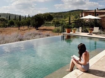
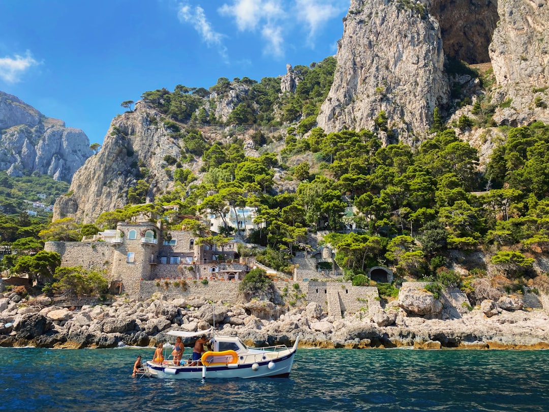
Capri's gorgeous coastline, amazing views, great shopping, and fantastic food means there's way more to do there than what you can squeeze into one day!
This guide is for the person who wants to luxuriate in everything Cpari has to offer, rather than fit it into one quick day. It has suggestions for how long to give the major areas and activities, as well as tweaks if you have 2 days or 3+ days.
In this guide, you’ll get:
- the major sights with notes on what you’re seeing and if they need advanced booking
- an interactive map to help navigate you to each spot
- the four major parts of the island and how to prioritize them
- explanation of transportation options on the island
- 4 restaurants and 1 gelato spot
- my favorite private boat company (for a reasonable price!)
- 2 shops for locally made products, including custom Capri sandals
- 3 beach clubs, 4 scenic overlooks, and 2 historic villas
- 3 hotels
- logistical sites you’ll need (ferry ticket counter, transportation pickup spots)
Foodie • People & Culture • Romantic • Wine • Beach • Relaxation
$20.00
3
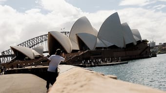
A travel photographer and food lover's guide to Sydney for boutique travelers! Complete with options for the perfect design hotels, suggestions for unique dining experiences, and art and history activities that highlight Australia's First Nations people. Come for the Opera House and beaches, stay for the cultural experiences here in Gadigal Country.
Art • Boutique • Luxury • Foodie • History • Design • People & Culture • Sustainable/Eco • Slow Travel • Photography • Wine • Beach • Mountain
Free
3
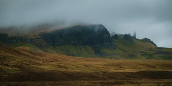
I travelled to the wonderful Isle of Skye in Scotland, visiting the Loch Ness and Inverness on the way, on a budget and without a car: pretty challenging but definitely doable if well optimised !
This is the general program, tried and true;
- Day 1️⃣: stop at a castle on the famous Loch Ness and maybe spot Nessie !
- Day 2️⃣: a full day on the Isle of Skye, staying in Portree, with an adventure to the Old Man of Storr
- Day 3️⃣: visiting Inverness on the way back
This guide will also include:
- how to go to the Isle of Skye, travelling from the south of Scotland (Edinburgh, Glasgow or Dundee) by bus
- a place to stay at (which I personally tried) and other possible recommandations, and places to eat
- made for students/travellers on a budget (around £170/person, and way less if you are under 22 and live in Scotland)
- an interactive map with all the locations attached.
Enjoy this guide with my own photos as illustrations !
Car-free • Backpackers • Adventure • Nature • Budget
$7.00
3
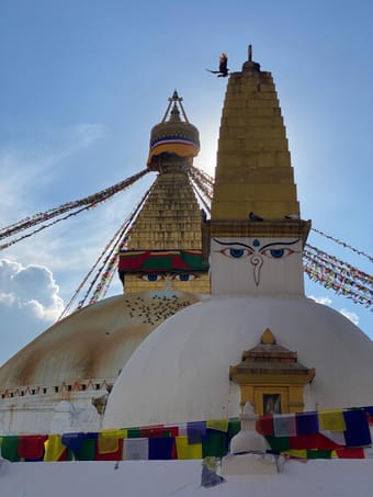
The wonderful city of Kathmandu in Nepal. This was my first stop before travelling to India and as always, I travelled with no expectations but I tell you ... it exceeded all my none existing expectations.
From discovering lovely coffee shops with the best organic Nepalese coffee to being stopped by strangers who simply wanted to have a chat, Nepalese people are some of the kindest I have met in my travels.
Let me share with you the touristic places I visited, as well as cafes and restaurants and make your trip easier. I did all the research so you don’t have to 😊
Accessibility • Backpacker • Couples • Digital Nomads • Family • Groups • LGBTQ+ • Plus Size • Female Solo • Vegan • Vegetarian • Adventure • Architecture • Budget • Coffee • Foodie • History • People & Culture • Photography • Slow Travel • Wellness
Free
3

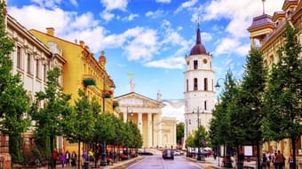
Lithuania - a small country near the Baltic sea. When someone asks me "Where are you from?" and gets the answer "Lithuania", usually people don't know where it is. So my goal with this guide is to show that my homeland is worth visiting and Lithuania has a lot to offer.
In this guide you'll find 10 most beautiful cities of Lithuania that are worth visiting.
50+ • Accessibility • Couples • Family • Groups • Wellness • Romantic • Road Trip • Relaxation • Photography • People & Culture • History • Foodie • Architecture • Budget
Free
3
Get ready for the perfect escape to a scenic hill station, when you're bored on the weekend and tired of the city traffic and pollution!
You can do this trip within a reasonable budget, depending on whether you're going solo or in a group.
Our budget for 3 people (by car) was:
₹6000 - ₹7000 per head
including tolls, petrol, food and stay.
The stay mentioned here is a luxury property, but you can always opt for something cheaper (though I recommend not to, as it will ruin the experience).
This guide includes:
💡 About Yercaud
🚗 How to Reach
🛎 Where to Stay
📌 What to Do
🍕 What to Eat
📲 Important Apps & Links for booking buses, trains or cabs
Groups • Couples • Families • Adventure • Luxury • Boutique • Nature • Slow Travel • Road Trip • Coffee • Mountain • Relaxation
Free
3

As of now, I've been Copenhagen twice:
• Once as a solo female traveller back in 2019 while backpacking around Europe,
• And the second time with family & friends when my husband and I got married at Copenhagen City Centre. 💍
This is honestly one of my favourite cities in the world and the place I've felt the safest while traveling.
The city is super safe, clean, people are the most welcoming and the food taste great (surprisingly).
I'm really looking forward to visit the city again.
Prepare for an extraordinary journey through the heart of the Danish capital by securing your copy of this comprehensive and user-friendly guide! 💎
P.S. This guide is a living treasure! Enjoy future updates and deeper insights without extra cost.
Got feedback or just want to share your Copenhagen experience? DM us anytime and tag us in your photos! 📸 @Tootly.travels
📲 Plus, it's not just a PDF—it's an interactive guide! Click any place or location, and instantly access directions on your phone's Google Maps app, make restaurant reservations, or book hotels. For even easier access, download the free Thatch app!"
Unlock Copenhagen's secrets and make your trip truly extraordinary. 🎉
Business • Backpacker • Car-free • Digital Nomads • Female Solo • Budget • Boutique • Adventure • Architecture • Design • Outdoors • Photography • Slow Travel • Road Trip • Sustainable/Eco
Free
3

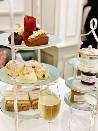
This lovely activity is an absolute must when you're in town - and these are all my tried-and-tested favourite spots. The list is short because I keep going back to them over and over again!
Finger sandwiches, warm scones and cute desserts with a pot of tea (and maybe a glass of champagne!) - what's not to love? This city is very good at pulling out all the stops for this wonderful British tradition.
Book in advance and prepare to spend around £50+ per person, but what a treat it will be! 🍰
Couples • Groups • Family • Foodie • Luxury • Romantic
Free
3
I've spent about the past two years being fairly nomadic traveling through Thailand, the Philippines, Indonesia, and a bunch of other countries in Southeast Asia, of which I must say that the Philippines is my number one choice for travel adventure. There is no better place. From the people to the landscapes, it has everything you're looking for.
Backpackers • Solo Female • Groups • Adventure • People & Culture • Nature • Slow Travel • Photography • Beach • Mountain • Relaxation
$17.00
3
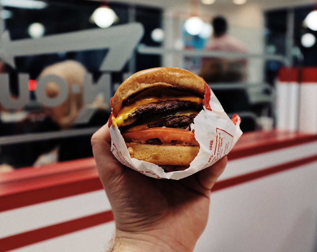
Finding a place to grab coffee, eat lunch, or enjoy a nice dinner while traveling is hard enough as is, but when you’re in a big city, the options are truly overwhelming.
While my guides are full of one-of-a-kind restaurants for certain neighborhoods, this Essential Eateries map includes the top few LA-specific chains that will help you eat like a local on the go. Not only that, but I include a backstory of each chain, my top menu suggestion, and what I consider to be the best location to visit.
This guide can also serve as a “What NOT to Eat” if you’re the kind of person who only wants to try single-location restaurants and want to determine if the place you’re interested in dining is a chain. Just pull up this map when you’re out and about to see where the nearest spots are when your tummy starts rumbling!
Get access to ALL the Los Angeles area locations of 34 regional chains, including:
☕️ 7 Coffee/Tea/Boba Shops
🥐 2 Bakeries
🥡 15 Fast-Casual Restaurants
🍽️ 5 Table Service Restaurants
🍦 5 Dessert Spots
Worried this info is out-of-date? Fear not! I'll be updating this guide every six months for accuracy, as well as to add new favorites I find along the way.
Gluten-free / Celiac • Vegan • Vegetarian • Budget • Foodie • Coffee • Beach
$15.00
2
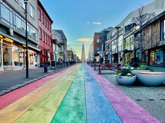
Reykjavík is the capital and largest city in Iceland. It’s also the northernmost capital in the world. The city, on the southwest coast of the island nation, is home to less than 150,000 people (that’s 60% of the total population). It’s by no means sleepy, though. It has a thriving art scene (music festivals, independent record stores, pop-up exhibits) and foodie scene (Michelin restaurants, organic wine bars, coffee culture). A grand church towers over the city. Candy-colored houses line the streets. Thermal swimming pools are gathering spots for most neighborhoods. Northern lights sightings are a real possibility (seasonally, of course). It’s also the jumping-off point for exciting adventures all around the Land of Fire and Ice. Pack for all seasons, as the weather changes frequently throughout the day--no matter what time of year it is. And be prepared to fall in love.
This detailed guide includes:
Places: islands, neighborhoods
Stay: hotels
Eat: bakeries, cafés, coffee shops, food carts & halls, ice cream, Michelin stars, restaurants
Drink: beer bars, breweries, cocktail bars, wine bars
Shop: beauty products, bookstores, chocolate shops, clothing boutiques, flea markets, outdoor wear, record stores, vintage clothing, wool products
Do: art museums, churches, concert venues, history museums, lakes, memorials, parks, peace stones, roads, sculptures, sports venues, squares, streets
Transportation: airports, bus terminals, car rentals, ferries
Note: I travel to Reykjavík quite frequently, so this guide is updated often.
Car-free • Art • Boutique • Foodie • People & Culture • Coffee • Design • Shopping • History
$30.00
2
The North Coast 500 is the magical route around the Highlands of Scotland.
This journey begins in Inverness, known as the gateway to the Highlands. We will drive to the West coast of Scotland, with the opportunity to include the Isle of Skye if you have some extra time. Then, we drive clockwise along the coast, taking in waterfalls, lochs, beaches, and the rolling hills of Scotland.
While driving the NC500, you will see the highlights of the route, with many opportunities for hikes, walks along the beach, and castles. As you drive you will be presented with scenic vistas of the rugged Scottish Highlands, whose views are known worldwide and are the real reason this route is so popular. You are encouraged to stop often at scenic points along the way to fully appreciate your surroundings.
This guide will include a full itinerary for an 11 day trip. It can be cut down to 9 days if you remove the Isle of Skye. If you don't do all the activities, you could potentially cut down some more time, but I have tried to limit driving to under 3 hours a day. This guide also includes suggestions on where to stay and where to eat dinner for each night of the trip.
Estimated budget of this trip based on 2 people sharing a room:
Accommodation (usually including a full breakfast) at an average £130 a night = £1,300
Dinner at an average £40 pp = £800
Car rental c. £40 per day = £440
Fuel for c. 830 miles at 148.5p = £1,235
Other (entry prices, parking) = £200
Total = £3,975
The food budget in particular in subject to where you go and what you order. This also doesn't include prices for lunch. Accommodation prices could also be reduced by staying in hostels rather than hotels/ B&Bs. Car rental prices were found on Kayak comparable site - these are variable.
Adventure • Road Trip • Beach • Mountain • Nature
$30.00
2

Interested in visiting Brussels but eager to get away from overly touristy places? Antwerp's the place for you, baby. Flemish people love this authentic gem and often go for day trips to shop and get inspired by its rich history and culinary hotspots. In this itinerary I've bundled when to go, where to go, and how to go. Carefully curated for you by a local. This city trip skips overrated tourist traps and lays out a step-by-step weekend like the locals.
🚉✈️ How long is this trip?
This itinerary is based on a three-day weekend, assuming you'll arrive on Friday evening and depart on Sunday. You can absolutely adapt this plan to a two-day stay, just make sure to read the advice I provide with my recommendations. This way you're in on best times for different activities.
🅰️ Why Antwerp?
- historic port city with rich history
- hotspot for gastronomic delights and lavish art
- like Brussels, but without the tourist traps
- home to one of the world's leading fashion academies and the internationally renowned Fashion Museum
- authentic Flemish (European) experience
- safe city (check out advice for female solo travelers below)
Car-free • Couples • Digital Nomads • Family • LGBTQ+ • Female Solo • Groups • Art • Coffee • Shopping • People & Culture • Boutique • Foodie • History • Luxury • Budget
Free
2

Try ThatchGPT