Results for Reykjavík
This 5-day fully packed itinerary is the ultimate road trip from Reykjavik to the Southern coast of Iceland! A map with drive times between each incredible stop is included. This guide covers the best waterfalls, hikes, and an ice cave tour, as well as the best bars in Reykjavik to meet other travelers. I did this trip with a friend, but it could easily be done solo!
Backpackers • Solo Female • Couples • Groups • Adventure • Nature • Roadtrip • Photography • People & Culture • Romantic
$15.00
1

Here's a list of experiences from Get Your Guide that'll help you get around & experience Reykjavik/Iceland without the need to rent a car.
All non-driving options all in one place.
the last 6 day tour will also include: hotel stay, breakfast, all transfers to/from airport & experiences, Golden Circe, South of Iceland, Blue Lagoon & Northern Lights Tour.
Backpacker • Car-free • Adventure • Budget • Outdoors
Free
1

Above is a picture of my dad and I snorkeling in the crystal clear waters of the Sifra rift in between two tectonic plates. Snorkeling is one of my favorite memories from our 10 day father-daughter trip to Iceland in June 2022.
I’ve used our experience to develop a family friendly itinerary with activities that entertain from energetic teenager to an adult in their 50s.
This itinerary includes a full 10 day plan with a packing list and links to companies that we tested and used including: rib boats, the blue lagoon, geysers, puffins, whale watching, snowmobiling on glaciers, snorkeling Sifra, hotels, and restaurants.
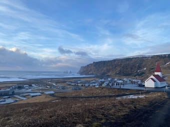
This itinerary is tried and tested, covering Iceland’s southern regions in addition to its capital Reykjavik. Other stops include the Golden Circle, Diamond Beach, Geldingalir Volcano, and Skogafoss.
$17.00
0

Above is a picture of my dad and I snorkeling in the crystal clear waters of the Sifra rift in between two tectonic plates. Snorkeling is one of my favorite memories from our 10 day father-daughter trip to Iceland in June 2022.
I’ve used our experience to develop a family friendly itinerary with activities that entertain from energetic teenager to an adult in their 50s.
This itinerary includes a full 10 day plan with a packing list and links to companies that we tested and used including: rib boats, the blue lagoon, geysers, puffins, whale watching, snowmobiling on glaciers, snorkeling Sifra, hotels, and restaurants.
This itinerary is tried and tested, covering Iceland’s southern regions in addition to its capital Reykjavik. Other stops include the Golden Circle, Diamond Beach, Geldingalir Volcano, and Skogafoss.
$17.00
0
Have you ever wanted to travel to Iceland or see the Northern Lights? Did you know Iceland is only a 5hr 50 min flight from NYC? I sure didn’t! If you want somewhere close to the US but feel like you’re WORLDS away, WITHOUT breaking the bank, THIS is the place for you!
Start off in Reykjavík and make your way on an awesome road trip, that will lead you all the way to the Jökulsárlón Glacier Lagoon and back, with iconic Waterfall stops, Black Sand Beaches featured on Game Of Thrones, The Blue Lagoon & More!
With this itinerary you have options that will keep you busy for days, seeing some of the most beautiful places on earth, in a short amount of time! I personally did this trip from a Thursday to Monday including the travel days! Let’s go adventure! ✈️
$20.00
0
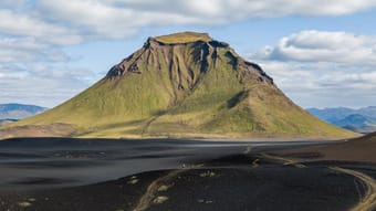
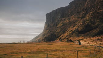
The Laugavegur Trail is probably Iceland's most famous hiking trail that showcases some of Iceland's most stunning natural landscapes. The trail stretches approximately 55 kilometers (34mi) from Landmannalaugar to Þórsmörk. Often the trail is combined with the Fimmvörðuháls, which adds another 25 kilometers to Skógar on the ocean in the south.
The terrain is extremely varied. You pass through black lava fields, along geothermal areas with steamy vents and boiling hot springs, over colorful mountains, by white glaciers, through lush green valleys and by some of Iceland's biggest waterfalls.
This guide includes the route and campsites as seen in my Youtube film and is suitable for beginner and experienced backpackers. It is suitable for both camping, as well as overnighting in the refuges along the way.
What this guide includes:
- A flexible itinerary for different lengths and difficulty levels
- Distances, best overnight (camping) options, and other useful waypoints
- Custom Google Maps with all the important locations, such as campsites, grocery stores, airports, trails, public transport stops, and viewpoints
- GPX-tracks of all the routes
- Practical information on how to get there, how to get around, when to go, trail conditions, weather, geography, and more.
- Detailed descriptions of the trekking route, including landmarks, terrain, and elevation changes.
Get an impression on YouTube/HarmenHoek. << video coming soon! >>
Backpacker • Adventure • Camping • Outdoors • Photography • Slow Travel
$15.00
5.0
(2)
46
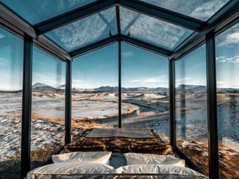
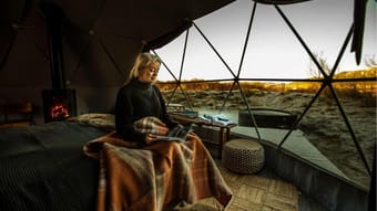
This guide will take you on a journey around the famous ring road that encircles the entire country, visiting some of the finest luxury hotels & lagoons the land of fire & ice has to offer.
Iceland doesn’t do outlandish luxury, here it’s the Scandinavia way. It’s all about the experience wrapped up in a minalmist no-fuss package where quality is king.
When money is no object, Iceland offers some truly unique places to rest your head & treat yourself. There are not many places on earth where you can sleep in glass huts gazing up at the norther lights or sleep so close to an active volcano you can feel the tremors. Once in a lifetime experiences can be found in abundance on this Atlantic island nation. .
LGBTQ+ • Digital Nomads • Plus Size • Backpackers • Vegetarian • Vegan • Solo Female • Gluten-free / Celiac • Accessibility • Halal • Car-free • Pets • 50+ • Couples • Groups • Luxury • Nature • Spas & Lagoons • People & Culture • Adventure • Architecture • Photography
$35.00
13
The Golden Circle is a 300km loop in Southern Iceland. I know it may sound daunting, especially if you are on a tight schedule to squeeze everything in. This guide will give you a schedule of the perfect way to plan a day trip in The Golden Circle. I’ve also added links of my experience in each activity and a recommend tour group if you aren’t ready to face the slippery roads during winter in Iceland.
Backpackers • Adventure • Nature • Budget • People & Culture • Photography
$7.97
11

Iceland is known for its many waterfalls, in fact, there are over 10.000 on the island. Most people head for Gullfoss, Seljalandsfoss and Skógafoss, this map helps you to escape the crowds and includes 10 of the lesser known but equally beautiful waterfalls Iceland has to offer.
Adventure • Nature • Road Trip • Budget • Sustainable/Eco • Photography • Mountain • Van Life
Free
8

In this guide I share the very best activities and operators in Iceland so you can have the most memorable experiences possible and make memories to last a lifetime!
What are my qualifications for this destination guide? - I organised and led an adventure tour for a global travel company here last year & got 10/10 reviews ✨
Car-free • Backpacker • Couples • Groups • Family • Digital Nomads • Female Solo • 50+ • Adventure • Outdoors • Overlanding • Photography • Road Trip • Relaxation • Romantic
Free
6

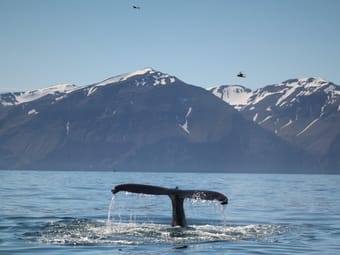
Everything you need to know about whale-watching in Iceland 🐋
50+ • Backpacker • Car-free • Couples • Digital Nomads • Family • Groups • LGBTQ+ • Plus Size • Female Solo • Adventure • Budget • Camping • Outdoors • Overlanding • People & Culture • Photography • RV • Relaxation • Slow Travel • Romantic • Road Trip • Sustainable/Eco • Van Life • Wellness
Free
6
Pedro Pereira
Available for hire
Icelandic odyssey - a weeklong adventure circumnavigating the island nation
Iceland, a land of fire and ice, beckons the adventurous traveler. This island nation, dramatically perched atop the Mid-Atlantic Ridge, boasts a raw, otherworldly beauty. Here, glaciers creep over volcanic peaks, waterfalls cascade into turquoise fjords, and geothermal pools bubble beneath the earth's crust.
This guide includes:
- introductory note
- places to visit (photo spots, museums and cultural venues, parks and gardens, open squares and others)
- restaurants (portuguese food and international cuisines)
- coffee and brunch places
- places for beer and drinks
- places for a night out
Get to see more from my travels on my Instagram (@pedralexpereira) and Flickr (flickr.com/photos/pedralexpereira)
Adventure • History • Outdoors • Overlanding • Photography • Relaxation • Road Trip • Romantic • Slow Travel • Sustainable/Eco
$20.00
3

This budget friendly trip will take you to some of the best places in Iceland that you absolutely cannot miss! The short and sweet 7 day adventure offers a taste of Iceland's natural beauty for those who love the outdoors, hiking, and a bit of relaxation.
Backpacker • Car-free • Digital Nomads • Groups • Female Solo • Family • Adventure • Budget • Outdoors • People & Culture • Photography • Relaxation • Slow Travel • Wellness
$6.50
3

Are you looking for a unique accommodation in Iceland?
Do you want this trip to be special?
Take a look at these cabins, hotels or villas located all over the island, and experience an unforgettable trip!
Architecture • Art • Boutique • Design • Wellness • Luxury • Nature • Romantic • Road Trip • Relaxation • Mountain • Photography • People & Culture
Free
3
Rent a car and drive along the South Coast to see many magnificent waterfalls and jaw-dropping glaciers. You'll stop by both famous and hidden attractions on the way too! I've added 18 sights you can visit, with time left to spare to relax and soak in the picturesque views.
Who needs a tour guide when you have a passion for exploration! Bringing you through a detailed 10 Days experience traveling along the southern coast of scenic Iceland :)
Check out my tiktoks @stayinblessed for a sneak peak of what you could see with my itinerary!
Adventure • Photography • Road Trip • Nature • Mountain • Beach
$30.00
0
Discover the magic of Europe in winter!
Escape the winter blues and immerse yourself in the enchanting beauty of Europe's most captivating cities. From the romantic charm of Paris to the festive spirit of Zurich, our guide unveils hidden gems and iconic destinations, perfect for cozy getaways or thrilling adventures. Experience breathtaking winter landscapes, indulge in culinary delights, and create unforgettable memories. Let us inspire your next winter escape!
50+ • Accessibility • Backpacker • Business • Couples • Digital Nomads • Family • Groups • LGBTQ+ • Plus Size • Female Solo • Architecture • Art • Boutique • Budget • Design • Foodie • History • Luxury • People & Culture • Photography • Romantic • Shopping
Free
0


Check out these top spots in Iceland that are either hidden gems or worth braving the crowds. Most are outdoor experiences, because the reason people visit Iceland is because of the natural beauty.
Sure, summer is the prime time to visit Iceland for the weather, but don’t be fooled—other seasons bring great things too (like the aurora). Iceland's weather changes every five minutes, its bad and good at the same time, and you might just have bad clothing if you're not having a great time. Positive attitudes are required here, and a bit of planning.
I’m Jules, and after a year living, studying, and exploring Iceland, I’m here to share my favorite unforgettable spots. I made a YouTube video showcasing months worth of footage in these locations for those who want a virtual tour. This list is based on that video.
I’ve sprinkled in some cool tips and hidden gems for each place to enhance your visit. Rest assured, I only recommend what I genuinely love. Hopefully we get along.
I’m also crafting a complete guide to every spot I’ve been in Iceland, but for now, I’m bringing you the very best. Less is more anyway, and less overwhelming.
Backpacker • Female Solo • Couples • Digital Nomads • LGBTQ+ • Outdoors • Adventure • Slow Travel • Sustainable/Eco • Photography • Road Trip
$15.00
0
This Wild Soul - Alice
Available for hire
Your ESSENTIAL Guide to Iceland - Where to stay and how to get around!
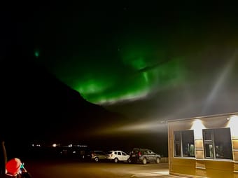
So you're off to Iceland, but what do you need to know before you go? In this Iceland destination guide I cover all the things you need to think about before you leave and any particular facts to be aware of. You also get my recommended list of apps and websites to help make your time there super smooth. It will help you check conditions for things like the Northern Lights or road conditions (which can be hazardous due to the weather and volcanic activity).
Backpacker • Couples • Family • Groups • Digital Nomads • Car-free • Female Solo • Vegan • Vegetarian • Adventure • Architecture • Art • Boutique • Budget • Foodie • Outdoors • Overlanding • People & Culture • RV • Photography • Road Trip • Shopping • Van Life • Wine
Free
7

In this guide, I'll share with you all the budget hostels I stayed at around the world and my honest opinion about them.
Most of my travels I did as a solo female traveller. And hostels were often the best option - cheap, safe, great places to meet another traveller.
📍Albania
📍Belgium
📍Bosnia and Herzegovina
📍Cape Verde
📍Croatia
📍Denmark
📍Finland
📍Germany
📍Iceland
📍Ireland
📍Latvia
📍Lithuania
📍Montenegro
📍North Macedonia
📍Poland
📍Portugal
📍Serbia
📍Slovakia
📍Spain
📍Turkey
📍United States
Backpacker • Car-free • Couples • Digital Nomads • Groups • Female Solo • Plus Size • Adventure • Art • Budget • Outdoors • History • Foodie • Coffee • Overlanding • People & Culture • Photography • Slow Travel • Romantic • Road Trip • Relaxation • Sustainable/Eco • Wellness
Free
18

Try ThatchGPT