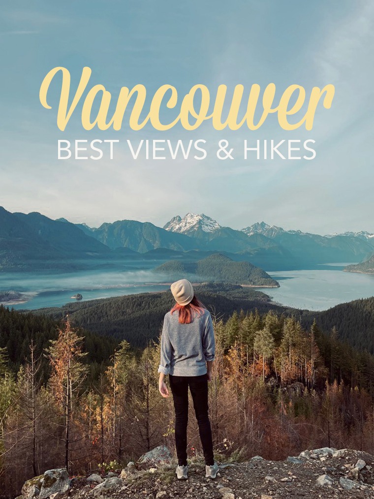
Before we get in, I just need to explain how I classified each place on this guide. They are divided into 3 categories:
• 📷 Viewpoints - you don't need to make any effort to get to these places, the main view is right there! I also included picturesque towns in this category.
• 🌿 Strolls - just a nice easy walk on a flat area, mostly in urban setting but not only, with very little effort required.
• 🌲 Hikes - a longer walk in the nature, with more effort to put into it. Again the focus here is not about the hike itself but about the rewarding view at the end! There are also 3 levels subcategories:
• Easy - relatively flat and not technical
• Moderate - some incline but not necessarily technical
• Hard - steep incline and most likely scrambling involved
Vancouver
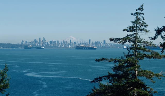
Why not start in Vancouver itself? It is a very green city, and it's incredible how easy it is to find places where you don't feel like you are in the city anymore. Depending where you live/stay, these places are literally in your backyard.
• Spanish Banks/UBC
🌿 Jericho to Acadia Beach
@chloeannabelle
Type: Stroll
Bus: 4, 7, 42, 44, 84
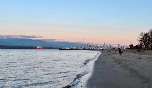
In my humble opinion, I think the best beach in Vancouver is Jericho Beach/Spanish Banks, because it's huuuge and gives you the best views of the mountains AND Vancouver's skyline. There is a dedicated path up to Acadia beach, but I think it's more fun to just walk on the sand and follow the ocean line! Just note that if you want to make this stroll a one way, you have to keep walking to Tower Beach, climb up the stairs and then catch a bus from UBC. It's often more worth it than just turning around, depending on how far you made it to, because there is no bus service along the way.

Details
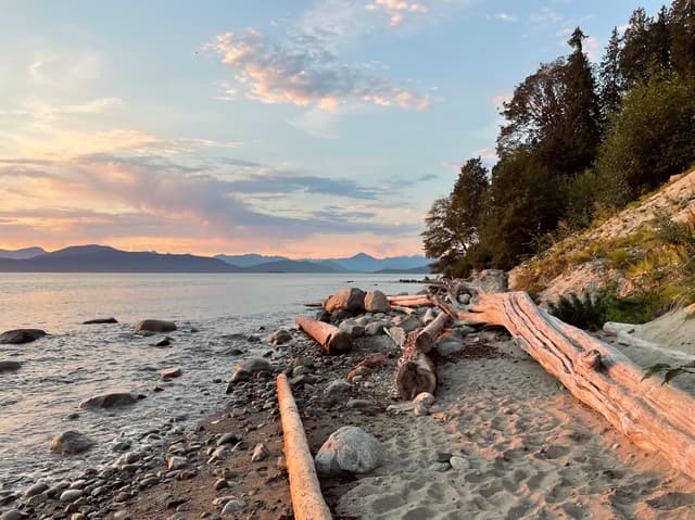
🌿 Wreck Beach
@chloeannabelle
Type: Stroll
Bus: 4, 14, 25, 44, 33, 49, 68, 84, 99, R4
You can add this stretch to the previous one to make it longer, or simply walk down to Wreck Beach and up on Tower Beach. There are a few steep stairs taking you to different points of the waterfront from the UBC campus. There is no path to follow, it's just a relaxing walk in the sand. Also know that this beach is clothing optional, so you won't be surprised!
Details
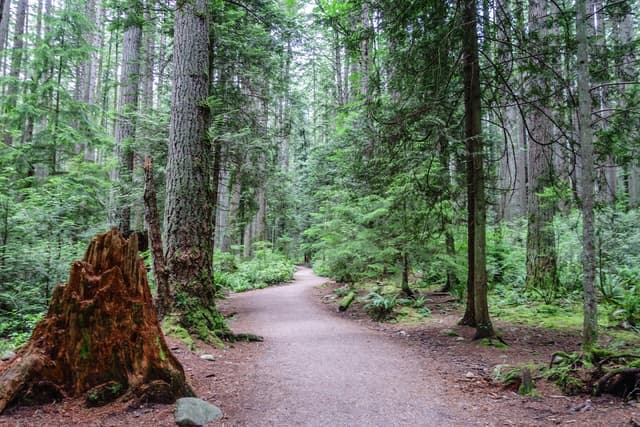
🌿 Pacific Spirit Regional Park
@chloeannabelle
Type: Stroll
Bus: 4, 14, 25, 44, 33, 49, 68, 84, 99, R4
This park is so massive I don't even have a specific trail to recommend. There are many different entrances and countless paths. Just choose the one you feel the most inspired by and enjoy a relaxing walk in the forest. This is a great option on a rainy day.
Details
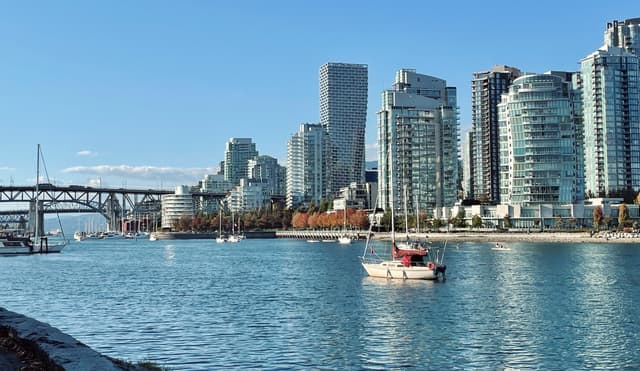
• False Creek
🌿 False Creek
@chloeannabelle
Type: Stroll
Bus: too many to count :)
This is the most urban stroll you can get, but walking along the water makes it super enjoyable! I would recommend walking the south part of it between Vanier Park and Science World, with a detour on Granville Island (or any stretch you feel like!) What also makes it really cool is that instead of turning around when you make it to the end or if you want to take a shortcut, you can hop in a water taxi that does multiple stops on False Creek for 4$.
Details
• Stanley Park
🌿 Vancouver Seawall
@chloeannabelle
Type: Stroll
Bus: 5, 6, 19, 23, 240, 241, 246, 247, 250, 253, 254, 257
This is without a doubt the most popular walk in Vancouver, but for good reasons, it is stunning any time of the day by any weather! It's the perfect balance between urban walking but still with amazing mountain and ocean views. I listed below all my classic spots on a Stanley Park walk, starting by Vancouver Rowing Club.
Details
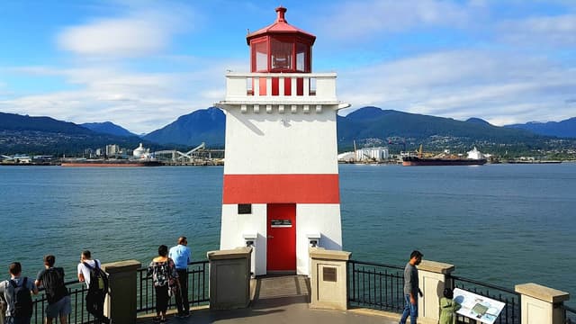
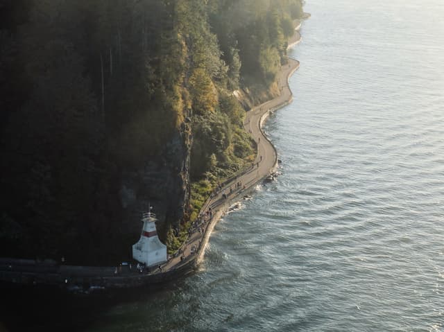
📷 Brockton Point
@chloeannabelle
This is the Eastern tip of Stanley Park, with a cool little Wes Anderson-ish looking lighthouse.
Details
📷 Prospect Point Lookout
@chloeannabelle
To get up there you will need to leave the asphalt path and follow Avison Trail. You get a bit of incline but nothing too hard, the cool views of Lions Gate Bridge make it worth the effort! You can also drive directly up there.
Details
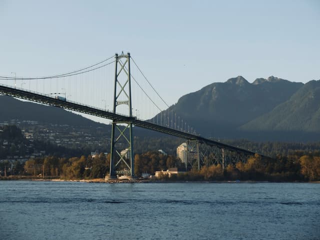
📷 Lions Gate Bridge
@chloeannabelle
Type: Viewpoint
Bus: 250, 253, 254, 257
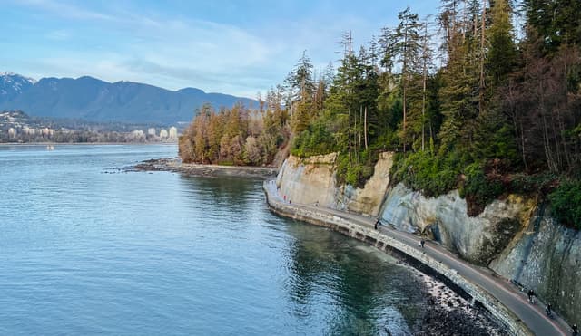
This might be a surprising one, but the views from the top of Lions Gate Bridge are actually quite unique and stunning from both side of the bridge - with Stanley Park's seawall winding down below and Vancouver's skyline right behind it, it feels like you're flying a drone! It's not the most pleasant walk on its own with the cars right next to you, but the views make it way worth it. Don't worry though, there is a dedicated path for pedestrians and bikes.
If you're coming from West Vancouver, there are bus stops quite close to the beginning of the bridge. But you must know that the best views are around the closest arche to Stanley Park, and it takes 30 minutes to cross the bridge in full. If you're coming from Stanley Park, the closest bus stop is much further away, and you must come from Prospect Point Lookout or the seawall. It doesn't really matter which side of the bridge you're choosing, as there is an under passage at both ends of the bridge, so you can enjoy all the different views!
Details
🌿 Siwash Rock Trail
@chloeannabelle
This is a hidden gem, not many people go there! From Prospect Point, make your way to the parking lot and after you passed it, start walking on Merilees Trail. Then take the next right on Siwash Rock Trail to the small viewing platform. This is a super quiet path, and in the end you will be treated with views from Siwash Rock and the Seawall from above, which I find pretty stunning.
Details
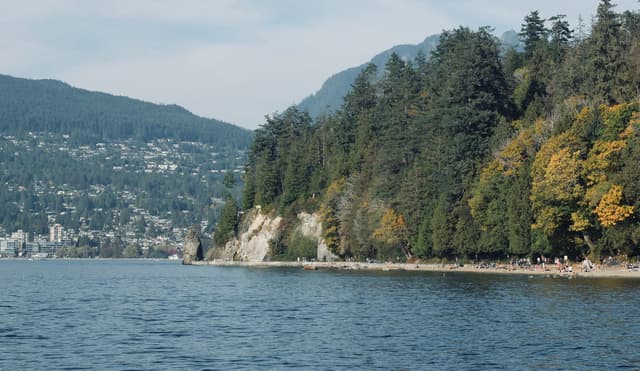
📷 Third Beach
@chloeannabelle
From the last point, keep walking on Siwash Rock Trail and take the next right back on Merilees Trail to slowly make you way down to Third Beach. This is a bigger and more secluded beach in Stanley Park, which to me makes it more enjoyable. This is a great spot to watch sunset and end your walk!
Details
• Queen Elizabeth Park
📷 The Photo Session
@chloeannabelle
Type: Viewpoint
Bus: Canada Line, 15, 25, 33
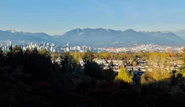
Queen Elizabeth Park has a couple paths, but what makes it worth it to me to come here is for the view from the plaza. But what some people don't know is that the best view is not from the main plaza, where it's mainly blocked by trees. You actually have to walk a little further out of the main path to a spot with funny statues called "The Photo Session". This is where you will get the most beautiful view of Vancouver's skyline against the mountains.
Details
• Burnaby
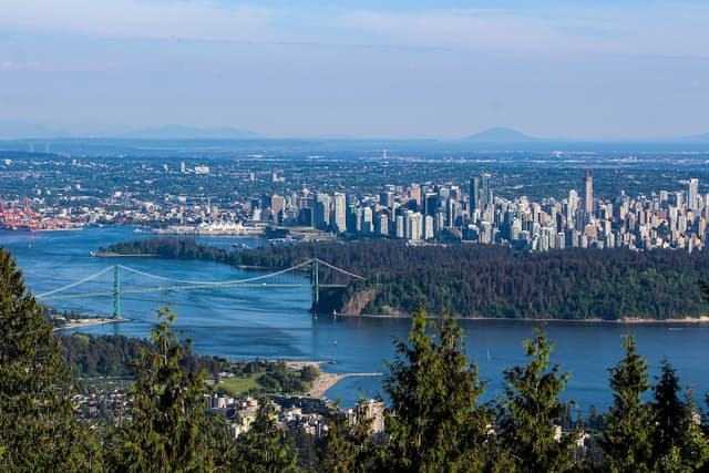
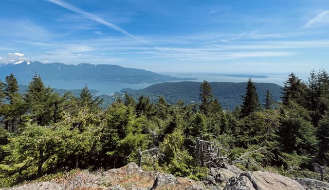
📷 Burnaby Mountain Park
@chloeannabelle
Type: Viewpoint + eventual Hike
Bus: R5, 143, 144, 145
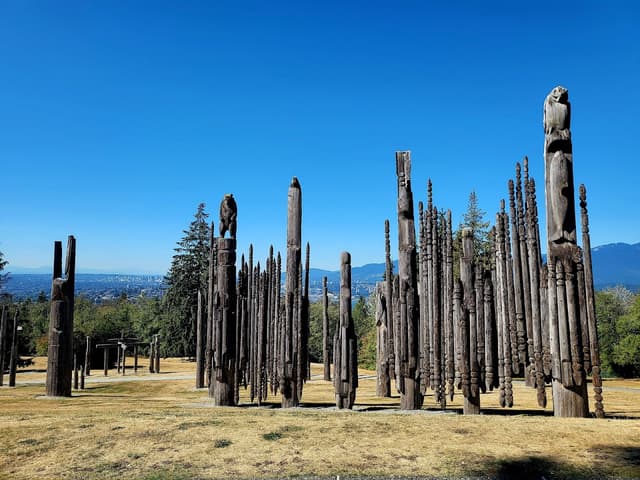
I know this is technically not Vancouver anymore, oops! Similarly to Queen Elizabeth Park, I selected Burnaby Mountain more for the viewpoint than for the actual hike, as you can literally drive up there, or take a bus to SFU Campus and walk a little. You will make it to an open area with totem poles installations and Vancouver's skyline in the distance. If you walk a bit around, you will also find a viewpoint on the Indian Arm and Deep Cove. Note that if you actually don't want to be lazy and want a bit more of a workout, there are tons of trails going through the forest that will take you up there!
Details
• Richmond
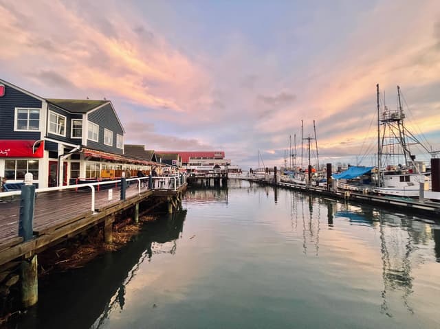
📷 Steveston Village
@chloeannabelle
Type: Viewpoint
Bus: 401, 402, 406, 407, 413
Steveston Village is a small community in the south of Richmond. It has a nice fisherman's wharf, but with its cute houses it's also known for being pictured as the fictional town of Storybrooke in the TV show Once upon a time!
Details
The North Shore
If you find Vancouver itself feels super connected to nature, wait to see the North Shore, you won't feel like you're close to the city anymore at all. Just cross the Lions Gate Bridge, as this is where it starts to get serious in terms of adventure! A lot of options are also still accessible by bus, which I find awesome!
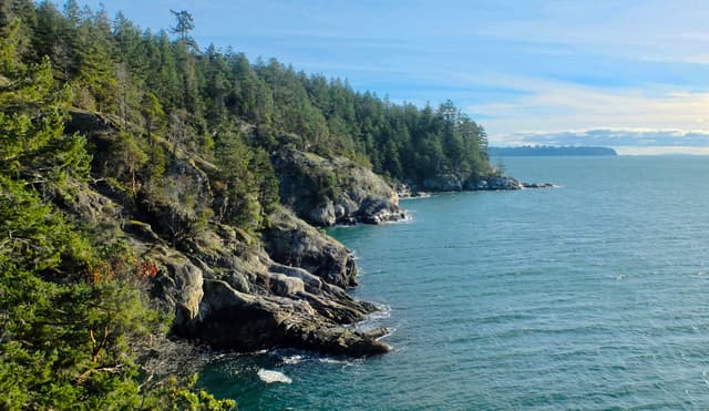
• Lighthouse Park
🌲 Lighthouse East View
@chloeannabelle
Type: Hike
Level: Easy
Bus: 250
Lighthouse Park is probably one of my favorite place outside of Vancouver. Its rugged coastline and picturesque lighthouse actually remind me a lot of Eastern Canada! It is a bit of a stretch to get there by bus, but it's absolutely worth it, even in rainy weather.
To get to the first viewpoint, follow the signs to East Beach. Many people miss out on this one, but it gives you a stunning view of Vancouver in the distance with, if the weather is clear, Mount Baker in the background! If you go all the way down on the rocks you can also see the lighthouse from a more unusual side.
Details
🌲 Lighthouse West View
@chloeannabelle
This is probably the main view you're looking for. It's actually pretty easy to miss, to get there you should follow the trail down to West Beach. I find that spot extra special for sunset!
Details
🌲 Juniper Point
@chloeannabelle
Many people don't bother going further West after finding the main lighthouse viewpoint, but I think it's a mistake and you should do the full loop! The trail to Juniper Point is so pretty, in the forest but by the water and surrounded by cliffs. After you have made it all the way there you're actually pretty close to finish the loop and you will be back at the parking lot in no time.
Details
• West Vancouver
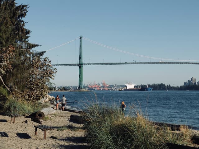
🌿 Ambleside Beach Park
@chloeannabelle
Type: Stroll
Bus: 250, 253, 254, 255, 257, R2
For a change of the Seawall, you can head to the other side of the Burrard inlet to West Vancouver. It has its own seawall looking towards Stanley Park, that you can start walking as far as Dundarave Beach. However, I think the best part is at Ambleside Beach Park, as it has the closest and best views of Lions Gate Bridge. This is just an easy stroll along the beach, but if you want to extend your walk for some more cool views, you can follow Spirit Trail to Lions Gate Bridge and actually walk on it towards Vancouver. You can get more info by looking at the Stanley Park places!
Details
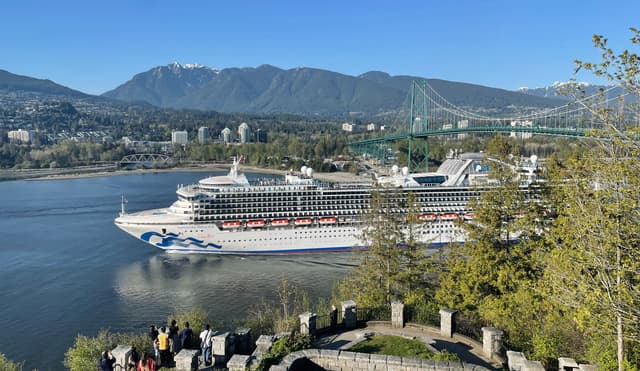
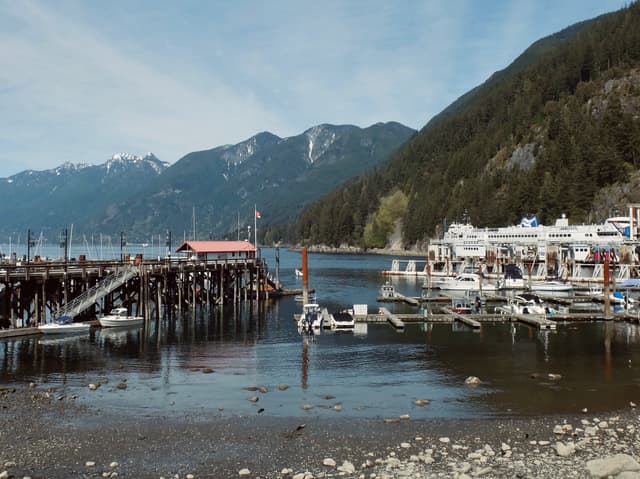
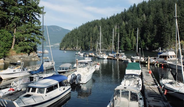
📷 Horseshoe Bay
@chloeannabelle
Type: Viewpoint
Bus: 250, 257, 262
Horseshoe Bay is a little community in West Vancouver mainly known for being a ferry terminal. But the little town has more to it, with a nice waterfront and picturesque docks nestled in the middle of the mountains.
Details
📷 Horseshoe Bay Secret Platform
@chloeannabelle
Type: Viewpoint
Bus: No (unless you walk 30 min from Horseshoe Bay)
This viewpoint is starting not to be so secret anymore with a recent exposure on social medias, but it's still a pretty unique spot. To get there, you need to take Horseshoe Bay Drive towards Squamish. At some point there will be a pull over area on the left side, that's where you should park (or on the side of the road but it's less recommended). Then you have to backtrack where you came from on foot, until there is some clearing on your right side. The platform is behind a small rocky formation. It gives you awesome views of Horseshoe Bay and the Howe Sound and it's the perfect spot to watch ferries coming in and out.
Details
• Cypress Mountain
📷 Trestle Bridge at the Mountain Path
@chloeannabelle
Type: Viewpoint
Bus: No
Trestle Bridge is a very little section of path overlooking the road going up to Cypress. It's a pretty cool place to take pictures, the view of Vancouver is pretty sick from here!
Details
📷 Cypress Lookout
@chloeannabelle
Type: Viewpoint
Bus: No
Just another viewpoint on the way up to Cypress where you can pull over and go. The view doesn't get old though, even at night!
Details
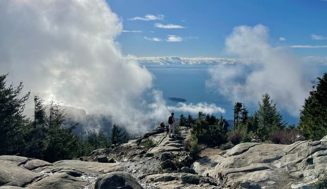
🌲 Eagle Bluffs
@chloeannabelle
Type: Hike
Level: Moderate
Bus: No
You now have to deserve your views with a bit more effort! But you will be nicely rewarded with panoramic views of Vancouver AND the Howe Sound! Starting from the main Cypress parking lot, this hike first takes you all the way up Black Mountain. This first section is not very technical, but it's quite steep. On top of the mountain there is a cute little lake, and you can even spot whiskey jacks (a type of bird) who would happily use you as a perch! From there it's going downhill to Eagle Bluffs. It's not as steep as the first section, but there is definitely more roots and it could be very muddy. I find this part very fun though!
Details
🌲 Bowen Lookout
@chloeannabelle
Type: Hike
Level: Easy
Bus: No
For a stunning view with minimal effort, this might be the best hike of this list, and it can be done any season! It starts in the meadow with pretty ponds before going uphill. It's a little bit steep, but really not for a long time. At some point you just have to make sure to make a left turn from the main trail and you're there already, facing the beautiful Howe Sound!
Details
🌲 Saint Marks Summit
@chloeannabelle
Type: Hike
Level: Hard
Bus: No
This is in my opinion one of the hardest hikes of this list, so definitely not for everyone, but oh my god the views of the Howe Sound that you're getting at the end, it's just spectacular!
The hike itself is fully into the forest, with mainly 3 steep switchbacks sections split by flatter parts. Only the end is a bit more technical with a lot of roots, but nothing too hard. When you make it to the top, there are 2 lookouts. To get to the first one you have to climb up a few last rocks and the panorama will unveil before your eyes. From here you can also get views of the second promontory. To get to this one, keep walking along the trail for another 50m, and this time go down some rocks. The lookout itself is quite small, there is not space for too many people. To avoid the crowds and also to get even more spectacular views, I would recommend doing this hike for sunset. It's not too hard as the most technical part will be the first section on your way down, so as long as you don't leave when it's pitch dark it will be fine. Don't forget a headlamp though!
Details
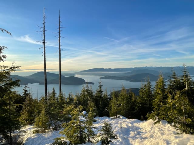
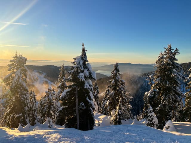
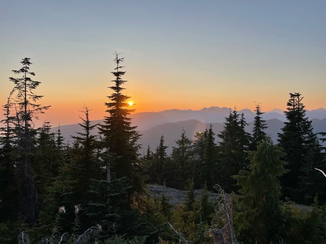
🌲 Hollyburn Mountain
@chloeannabelle
Type: Hike
Level: Moderate-Hard
Bus: No
This is the best winter wonderland hike in Vancouver! Starting at the Nordic area of Cypress Mountain, it's a popular trail for snowshoeing, although if the snow is packed enough, microspikes are sufficient. But note that you NEED microspikes. The trail gets extremely steep, especially on the second half, and hiking up without them would be nearly impossible. But once you make it to the top you will be rewarded with 360° views of Vancouver, Cypress ski hills and the North Shore mountains. It's even more special at sunset on a clear day! On the way down, you can make it more fun by carefully bum sliding the steep trail, so bring a garbage bag or waterproof pants!
Details
• North Vancouver
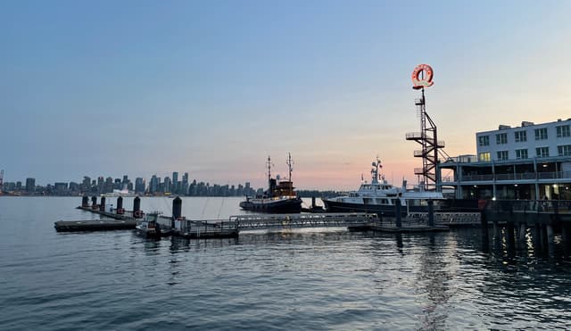
📷 Lonsdale Quay
@chloeannabelle
Type: Viewpoint
Bus: Seabus, 228, 229, 231, 236, 249, R2
To see Vancouver's skyline from another perspective, the easiest way is to go to the Waterfront Station and take the seabus to North Vancouver, which is part of the public transport system! You will get to Lonsdale Quay, which is a really nice place with a market, cafes and restaurants. You can walk along the pier and enjoy the views of Vancouver on the other side of the water. It's pretty special for sunset especially!
Details
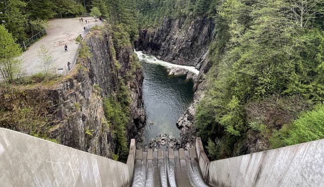
🌲 Cleveland Dam
@chloeannabelle
Type: Hike
Level: Easy
Bus: 232, 236, 247
I would almost consider this hike as a hidden gem, as I don't find it so popular at all. It's also a great option for a moody day! It starts at Capilano Lake, which is a pretty nice sight on its own, and on the top of the dam. The dam itself is quite an impressive structure, but that melts pretty well in the environment in my opinion. The hike will take you down along the river into a nice mossy forest, with more cool viewpoints of the dam from below. There is even a hatchery that you can visit for free!
Details
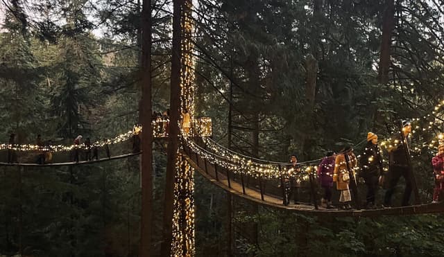
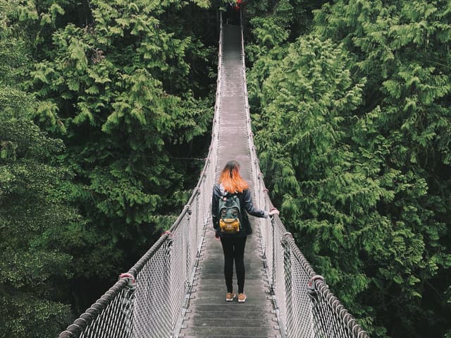
🌿 Capilano Suspension Bridge Park
@chloeannabelle
Type: Stroll
Bus: 232, 236, 247, free shuttle from Downtown
Disclaimer! This is a VERY popular tourist attraction, that is also very overpriced (70$). There are other options to see similar places for free (Lynn Canyon, see after). However, I think it's worth visiting Capilano ONLY during Christmas and Halloween time. This is when they have many lights on, which makes it extra magical compared to other places and the only reason why you should be spending the money. If you're a BC resident, you should also know that a year pass costs the same price as a single entrance! So you should better go for that option and go multiple times a year to make it worth it.
Price and crowd aside, I find this place really magical. There are a couple different trails in the park, my favorites are the treetop and the cliff walk. The lights are totally enhancing that mystical BC forest atmosphere, especially on a moody day. I would recommend going at the end of the day, but before it gets dark. Many people only come when it's fully dark, but I think they're loosing a lot of that misty forest magic.
Details
• Lynn Valley
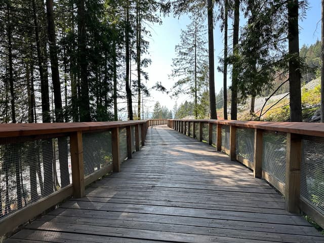
🌲 Lynn Canyon Suspension Bridge
@chloeannabelle
Type: Hike
Level: Easy
Bus: 227
Same suspension bridge as Capilano, but for free! But the park itself is not very comparable though, it has its own kind of magic. Most of the trails are boardwalks in a mossy forest, following the river and waterfalls. The main loop that people do is to the right after you cross the bridge. It's another great option for a rainy day.
Details
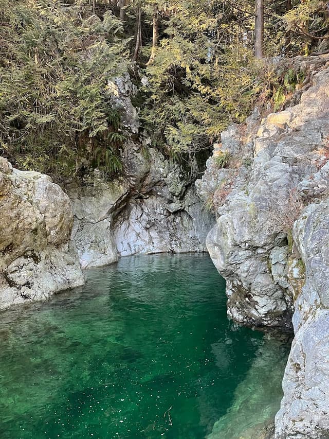
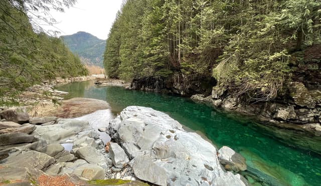
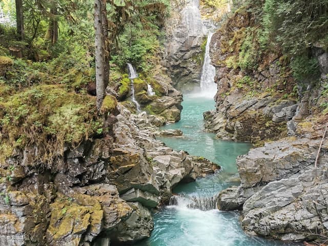
🌲 30 Foot Pool, Lynn Canyon
@chloeannabelle
To add to your hike in Lynn Canyon, you can take a left after you cross the bridge and follow the trail to the 30 Foot Pool. It's a section of the river where the water is emerald! It makes for a refreshing spot to swim in summer.
Details
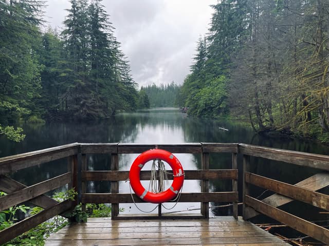
🌿 Rice Lake
@chloeannabelle
Another extra leg after the 30 Foot Pool, that will take you to a cute little lake that you can tour. Note that it has its own parking if you just want to do the lake.
Details
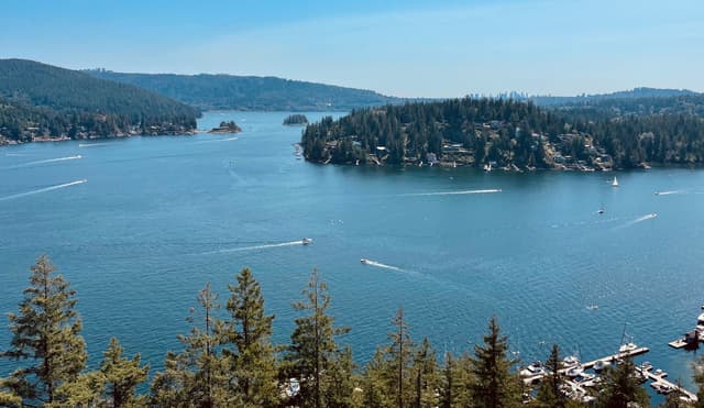
• Deep Cove
📷 Deep Cove
@chloeannabelle
Type: Viewpoint
Bus: 211, 212
Deep Cove is a quaint little community in North Vancouver with a very picturesque watefront.
Details
🌲 Quarry Rock
@chloeannabelle
Type: Hike
Level : Easy-Moderate
Bus: 211, 212
Quarry Rock might be one of the best hikes around Vancouver if you don't have a car but still want some awesome views with minimal effort. The trail has a lot of ups and downs and many roots, but it's still relatively easy. You will be treated with stunning view of the Indian Arm and its little islands, with Metrotown in the distance. It's a good option for a sunset. As a bonus, on your way down you can chill in Deep Cove, which is a very quaint town!
Details
• Mount Seymour Provincial Park
🌲 Dog Mountain Trail
@chloeannabelle
Type: Hike
Level: Easy-Moderate
Bus: No
It's really a shame that Dog Mountain is not accessible by public transport, because as a view/effort ratio, it's unbeatable! It barely has any incline as you already start at the top of Mount Seymour ski resort. It is a little technical though, with lots of rocks and roots, but it's very manageable. Once you make it to the end, you get a panoramic view of the whole Lower Mainland, Grouse Mountain, and if you're lucky with clear skies, Mount Baker in the distance. When I did this hike the weather wasn't the best, but I was actually in the clouds, which was still super cool and moody! It's also a great option for sunset, but a headlamp is a must have!
Details
• Coquitlam
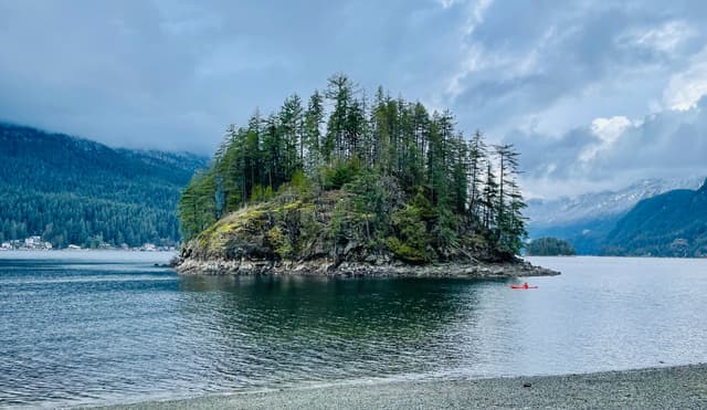
🌲 Jug Island Beach
@chloeannabelle
Type: Hike
Level: Easy
Bus: 181, 182
If you're looking for a hike to do on a rainy day, search no more! If you don't have a car it's a bit of a journey to get there, but it's worth it. The bus will actually drop you right at the trailhead. If you're driving there though, don't put the trailhead in your GPS and park at Belcarra Regional Park. There are two different roads to get there and it's very frustrating when you're on the wrong side of the parking lot (true story).
The trail has a little bit of ups and downs but is pretty straightforward. At the very end it gets much steeper downhill, and you will just pop out of the forest facing Jug Island. The island itself is not accessible (unless you have a kayak), but it's such a picturesque sight with the mountains in the background, that in my opinion even gets enhanced with moody weather! If the tide is low you can venture on the rocks on your right for some different views.
Details
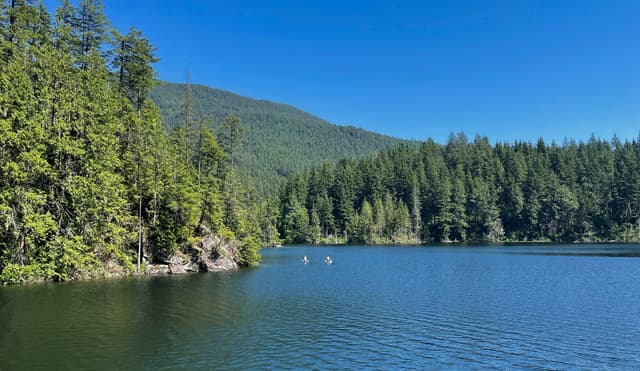
🌲 Buntzen Lake Trail
@chloeannabelle
Type: Hike
Level: Easy-Moderate
Bus: 179
Just like Jug Island, it's a bit of a journey to get there by public transport, but at least it's possible so no complaints! With a car though, be aware that in summer you need to book in advance a day pass (for free) as they limit the number of visitors.
Buntzen Lake is a beautiful lake surrounded by steep mountains. It's quite big, so plan some time to do the loop (3-4h). The left side has some significant incline and is mostly into the forest, but the right side is almost flat and alongside the lake's banks.
Details
Fraser Valley
This section takes you further into the mainland, so you will say goodbye to the ocean views, but the lakes and mountains are still there! You definitely need a car to access these places though, and count at a least 1 hour drive.
• Golden Ears Provincial Park
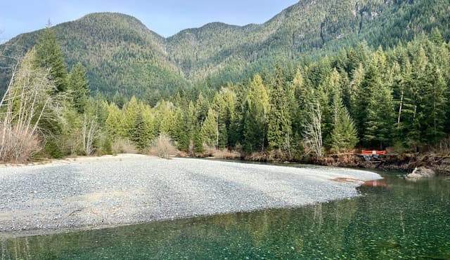
🌿 North Beach Trail
@chloeannabelle
Type: Stroll
Bus: No
Note that to access Golden Ears Provincial Park in summer you need to book in advance a day pass (for free).
This trail is super easy and takes you along an emerald color river to the banks of Alouette Lake, which has stunning views of the mountains around.
Details
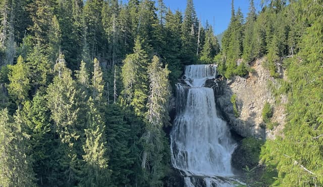
🌲 Lower Gold Creek Falls
@chloeannabelle
Type: Hike
Level: Easy
Bus: No
Note that to access Golden Ears Provincial Park in summer you need to book in advance a day pass (for free).
This is another very easy trail going along an emerald colored river with spectacular mountain views. It leads to a beautiful waterfall (Lower Falls). There are some Upper Falls as well, but the trail to it looks much sketchier so I haven't been there.
Details
• Mission
🌲 Hunter Lookout
@chloeannabelle
Type: Hike
Level: Moderate
Bus: No
This is definitely the hidden gem of this list! Located way out in Mission, the trail follows a logging road, that is pretty steep at the beginning, then levels out before another steeper part at the end. It's not the most exciting hike on its own, but the views of Stave Lake at the end are absolutely worth it. And the best part about it is that it's still a well kept secret, so you will most likely have the place for yourself!
Details
• Langley
📷 Fort Langley
@chloeannabelle
Type: Viewpoint
Bus: 509, 562
Fort Langley is without a doubt the cutest and most picturesque town outside of Vancouver! It has a historic site that you can visit, but just wandering the streets will make you feel that you traveled in time. There are also a ton of nice shops and cafes!
Details
• E.C. Manning Park
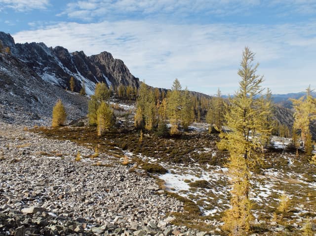
🌲 Frosty Mountain
@chloeannabelle
Type: Hike
Level: Moderate-Hard
Bus: No
We are definitely breaking the 1.5h drive limit from Vancouver, with this park being 2.5-3h away from the city. But trust me, it's a must do for the Fall season! It's the closest place from Vancouver to see golden larches, that you are more likely to see in the Rockies. For this reason, it's a very popular hike, so plan to leave early, as parking can already be full by 8:30am!
You must know that this is a very LONG hike (20km) with a significant elevation gain. For the most part it's not particularly technical or extremely steep, but there is definitely a steady incline all the way. The section where you can see the larches, also called the meadows, is only starting after 3/4 of the trail is behind you. But after you reach it, it's a real fall wonderland with thousands of larches everywhere! If you feel like going all the way to the top of Frosty Mountain, it becomes more like scrambling than hiking, and a bit sketchy with loose rocks. To me the best part is about the larches, so I didn't mind turning around without making it to the top! A great thing about this hike is that "the journey is the destination". You're not hiking for a specific viewpoint at the end of a trail, as all the trail is filled with beautiful views all around.
Details
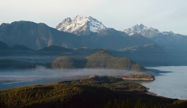
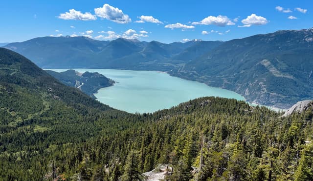
Howe Sound
Back to the ocean! The Howe Sound is a body of water extending from the Salish Sea to the town of Squamish. It's home to a bunch of islands that you can explore, or just get spectacular views of from other hikes. Some of them here are even accessible by public transport.
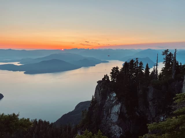
• Bowen Island
📷 Snug Cove
@chloeannabelle
Type: Viewpoint
Bus: 250, 257, 262 + Ferry
Snug Cove is your entry point to Bowen Island, which you can access even if you don't have a car! The ferry from Horseshoe Bay costs 11.60$ return as a passenger and the crossing takes 20 minutes.
It will take you to Snug Cove, a cute little village with many cafes and restaurants, it's very pleasant to walk around.
Details
🌲 Mount Gardner
@chloeannabelle
Type: Hike
Level: Hard
Bus: 282
This hike takes you to the top of Bowen Island! The trail head is at Killarney Lake. If you can manage to catch the bus that's great, but you should know that the service is very limited. If you can't catch one it's not such a big deal, you can actually walk to the trail head from Snug Cove and add another 2.5 km to the hike.
The hike itself is not super technical but is a steady uphill for around 3 hours and ends with a rope section. When you get to the top you're rewarded with 360° views, the Sunshine Coast on one side, and Vancouver on the other. There are two wooden platforms facing each view where you can chill. For the way down, it's up to you if you want to go back the way you came from or follow Skid Trail to do a loop, both options are equivalent.
Details
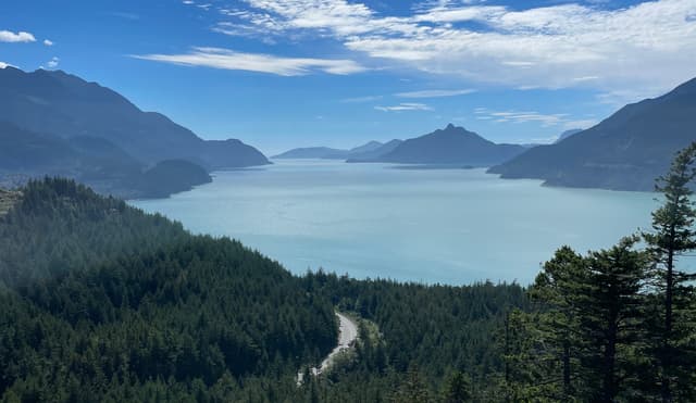
• Sea to Sky Highway
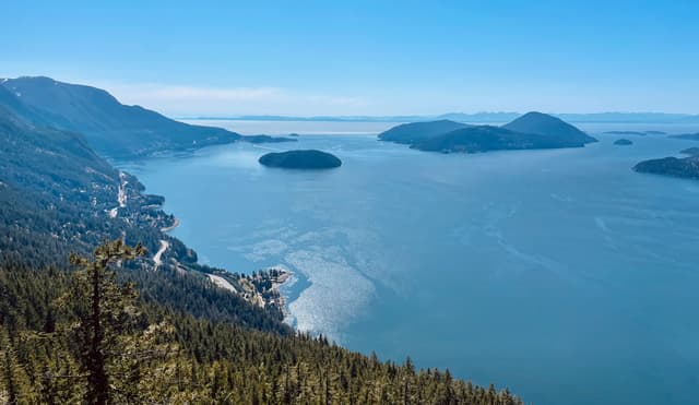
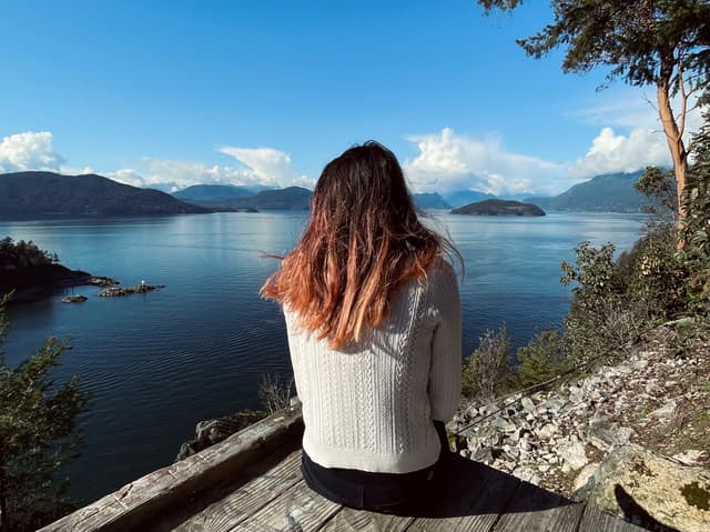
🌲 Tunnel Bluffs
@chloeannabelle
Type: Hike
Level: Moderate
Bus: 262
This is in my opinion the hike with one of the best views around Vancouver! If you're getting there by bus, plan some time ahead because it's a bit of a journey. You should also know that to get to the trail head you have to walk an extra 1.6 km uphill from the bus stop. If you're getting there by car, there are also a few tweaks to know: you're aiming for the Sunset Trailhead parking (paid parking), but it has very limited spaces and it gets full quickly. Your other option would be to try to find a parallel parking spot on Mountain Drive a bit further down (paid parking). If that's also not available, you can park on the Lions Bay Elementary School overflow parking (free).
About the hike itself, it's a steady uphill following a logging road for the first 2 km. Then it levels out and gets completely flat for the rest of it, with a little bit of scrambling at the end. Note that there are also two streams to cross with funky log bridges. When you make it to the viewpoint you will be treated with the most spectacular panoramic view of the Howe Sound!
Details
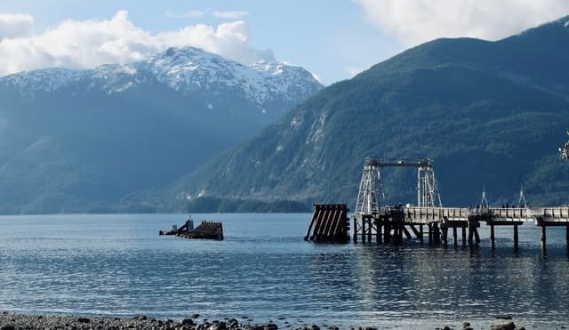
📷 Porteau Cove
@chloeannabelle
Type: Viewpoint
Bus: No
This is a viewpoint where you can pull over directly on to enjoy views of the Howe Sound from sea level. On a sunny day you can often spot sea lions sunbathing on the pier structures!
Details
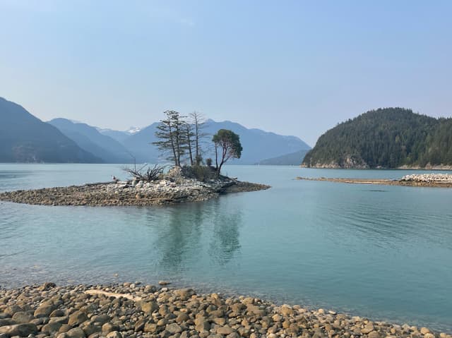
📷 Furry Creek
@chloeannabelle
Type: Viewpoint
Bus: No
Furry Creek is THE hidden gem of the Sea to Sky Highway. It's not a popular stop at all and not so easy to find, but to me it offers the most magnificent views of the ocean surrounded by the mountains with a turquoise water. There is a tiny islet in the middle of the bay that gives such a peaceful atmosphere to the place. If you have a kayak or a paddle board, this is definitely the best place in BC to go!
Details
🌲 Quercus Lookout
@chloeannabelle
Type: Hike
Level: Easy-Moderate
Bus: No
Murrin Provincial Park is a popular park for rock climbing and bouldering. This hike takes you into the forest along the boulders and eventually gives you an amazing view of the Sea to Sky Highway! This hike has a great effort/view ratio in my opinion.
Details
Squamish
Squamish is another BC town for the outdoor lovers - climbers, mountain bikers, kite surfers, and of course hikers. It takes approximately one hour to drive there from Vancouver. There is a private bus connecting Squamish to Vancouver, but it won't take you to the trail heads.
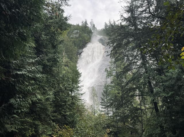
🌿 Shannon Falls
@chloeannabelle
Type: Stroll
Bus: No
Couldn't be easier, from the parking lot you just have to walk for a couple hundred meters to get to the falls. They are cascading down 335 m, it's pretty impressive to see!
Details
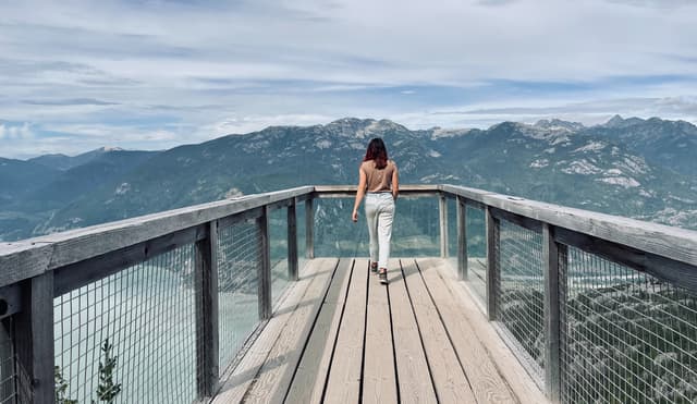
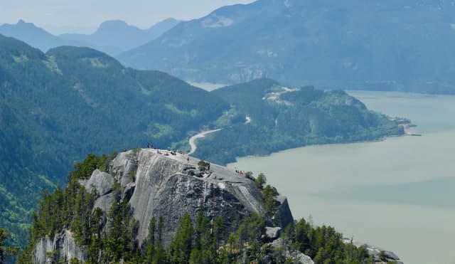
📷 Sea to Sky Gondola
@chloeannabelle
Type: Viewpoint or Hard Hike
Bus: No
There are 2 routes to go up this mountain: a challenging hike or paying 68$ to take the gondola. I always chose the gondola option, so I can't tell you much about the hike up, but I can refer you to an Alltrails link.
However I didn't pin this place for the gondola lift (which is still very cool on its own), but because there are more things to do and see once you get to the top! First, right when you get off the gondola, there's a viewing platform and a really cool suspension bridge!
Details
🌿 Panorama Trail
@chloeannabelle
Type: Stroll
One of my favorite trails on top of the Sea to Sky Gondola is Panorama Trail. It's an easy walk through the forest that takes you to a really cool cantilevered platform overlooking the impressive Chief mountain!
Details
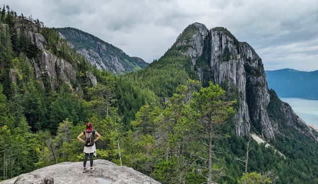
🌲 Stawamus Chief
@chloeannabelle
Type: Hike
Level: Hard
Bus: No
The Chief is THE symbol of Squamish. It's a massive granite monolithe with vertical faces, and probably one of the most popular hikes to do around Vancouver. It's also a famous spot for rock climbing. There are 3 different peaks that you can hike to, you can do all 3 together in one go or just choose one of them!
I will tell you about my personal experience doing 2nd and 3rd peak. The trail is the same for all of them at the beginning anyways, with endless stairs to start with. It then splits to go to 1st peak, which is usually the most busy viewpoint, as a lot of people are just doing this one.
I chose to skip it to avoid the crowds and because the view is supposedly better from 2nd peak. A common thing for both of these peaks though is that there are ladders and chains sections to get to the top, so you must be aware if you have some mobility issues. But the view is way worth it, with panoramic views of Squamish, the Howe Sound AND 1st peak below.
Getting to 3rd peak is not so much of a stretch from 2nd peak, and you already did most of the elevation. In my opinion it's worth doing as it gives you different views on the other side of the mountain, facing Slhanay Peak.
However, the way down from 3rd peak is much more technical, as you're basically just scrambling down big rocks, there's barely any trail to follow, and it takes a very long time. It eventually joins back to the stairs from the beginning.
Details
🌲 Slhanay Peak
@chloeannabelle
Type: Hike
Level: Hard
Bus: No
This hike could be considered as a hidden gem, as it's not popular at all and gives you unique views of The Chief!
However, you need to be prepared: it is extremely steep (basically scrambling all the way up and down) and poorly marked, so download the AllTrails map and keep a close eye on it while hiking. There are 4 main viewpoints: the first one on the way up gives you some obstructed views of Squamish and a bit of The Chief on the side. Tony's Lookout is the best viewpoint - if you can find it. AllTrails is marking it correctly now, but it wasn't the case when I hiked it so I was pretty bummed to have missed it! You can hike all the way to the peak if you feel like it, but the view doesn't get any better and it is quite obstructed, so I would suggest turning around after Tony's Lookout. The last viewpoint on the way down brings you out onto a rocky outcrop that is almost just as good as Tony's, with panoramic views of Squamish and The Chief in front of you!
Details
🌲 Mamquam Falls
@chloeannabelle
Type: Hike
Level: Easy
Bus: No
This little hike along the river is still quite protected from mass tourism, it takes you to a waterfall with stunning turquoise color waters.
Details
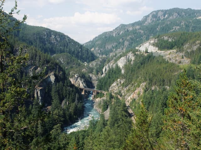
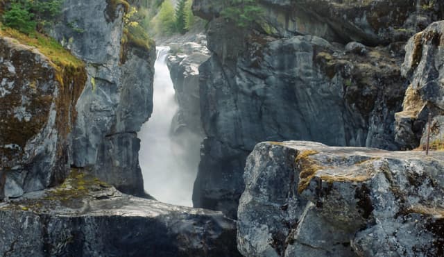
🌲 Cheakamus Canyon
@chloeannabelle
Type: Hike
Level: Easy-Moderate
Bus: No
This hike is definitely a hidden gem in Squamish, as few people have even heard about it. Yet it offers unique views of train tracks overhanging inside a canyon, with a turquoise color river running down below!
The hike starts around Paradise Valley, a little further after Squamish. The last section of the drive to there is on a gravel road, but is pretty well maintained and manageable with any car. The main parking lot is for 2WD, but if you have a 4WD you could even drive a bit further, just know that the road is getting really super bumpy. Even if you don't have a 4WD, you can still enjoy walking along the river before the trail actually starts. There is definitely some incline all the way, but it's never really steep and not technical at all, the trail is very easy to follow. However, what might make it harder is if it's hot, as it's very little shaded. About halfway up there is a lake where you can cool down. Really soon after the lake you will start getting views of the canyon, with various viewpoints to catch the train tracks. The last viewpoint is when you see the bridge in the distance. The trail keeps going, but it's only joining the highway and there are no more viewpoint that would be worth it, my recommendation is to turn around after this point. This is a hike that I would even suggest to do when the sun is not out, to better see the canyon from a photographic point of view.
extra tip: if you feel like having a pre or after hike snack, there is a place on the way to there called Fergie's Cafe, it's a really trendy place into the forest with a very neat architecture!
Details
Further North
Driving past Squamish, this last section takes you deeper into the forever snowy mountains of British Columbia, towards the ski resort of Whistler. There's a lot of lakes and waterfalls to see, and if you're lucky you might see bears on the side of the road! Just like for Squamish, you definitely need a car to access these hikes.
• Before Whistler
🌲 Panorama Ridge
@chloeannabelle
Type: Hike
Level: Hard
Bus: No
I haven't done this hike yet as it's particularly long and challenging, but it's an absolute classic that will take you to the most spectacular view of Garibaldi Lake, surrounded by snowy peaks! Note that you can split the hike in half and camp at the bottom of Garibaldi Lake
Details
🌿 Brandywine Falls Provincial Park
@chloeannabelle
Type: Stroll
Bus: No
This is a very quick stroll in the forest leading to an observation deck overlooking a very picturesque waterfall. The trail eventually takes you to another viewpoint overlooking Daisy Lake. To the left of the trail end, there is a way to get down at the bottom of the waterfall, but it's unmarked.
Details
📷 Alexander Falls
@chloeannabelle
Type: Viewpoint
Bus: No
This is a viewpoint you can pull over to, and it's a very hidden sight that not many people know about! The 10 km quiet road leading to it is also a good bet if you want to try to spot bears!
Details
• Past Whistler
🌲 Nairn Falls Provincial Park
@chloeannabelle
Type: Hike
Level: Easy
Bus: No
We are actually breaking the 1h30 drive limit from Vancouver here, as this waterfall is located 2 hours away. But if you are already in the area this is a great easy hike along a turquoise colored river leading to another waterfall.
Details
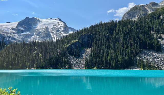
🌲 Joffre Lakes
@chloeannabelle
Type: Hike
Level: Moderate
Bus: No
Last but not least, Joffre Lakes is a good 3 hours drive from Vancouver, but it's a sight not to be missed! It's actually not one but 3 lakes in one hike! With their stunning turquoise color, it almost gives you a taste of the Rockies.
The first lake is very easily accessible from the parking lot. Then there is definitely a bit of incline, but it's not very technical. The second lake is in my opinion the most beautiful of the three, surrounded by trees and with the glacier in the background. If you want to take a cool picture, there is a log half submerged in the water that you can walk on, just don't fall into the water! The last lake is a short distance away and allows you to see the glacier from closer.
Note that this is a very popular hike, so I would advise to start as early as possible! It's also mandatory to book a pass 3 days in advance in summer (for free), and it usually sells out so plan ahead!
Details
* * *