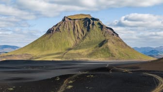
Thórsmörk


Ask ThatchGPT
Suggest a local expert to plan my trip
Suggest an unique itinerary for my Iceland trip
What foods do Iceland locals eat
What are some true hidden gems in Iceland
Help me brainstorm trip ideas for Iceland
Help me plan a family-friendly trip to Iceland
What people say
Joey Helms
"Thórsmörk, or the valley if Thor, is another popular destination in the highlands for locals and visitors alike. With many campgrounds and hiking trails it is very popular during summer. Heck, some are even trekking the highlands from Thórsmörk to Landmannalaugar which takes about 3-4 days (or you run it during the annual trail run between the two locations). To get to Thórsmörk you can either take a bus (that will drop you at the main campground/at the main trail heads) or on F249 in your own 4x4 river worthy car, since you have to cross a few rivers. The one river you don't want to cross (unless you have a mountain vehicle and have experience in crossing strong current) is Krossa. A pedestrian bridge allows you to cross it by foot and from there it is about 30 mins to hike to the campground.
PHOTO TIP
If you are in Thórsmörk the first time I recommend hiking up Valahnukur (elevation ~1000m). From the peak you have 360 degree view on the rivers that carve their way like arteries through the valleys, the surrounding mountain ranges, including the infamous volcano Eyjafjallajökull, and the rock formations on the mountain itself which provide a very intriguing foreground. Especially if you are a daredevil and partially climb up one of those formations (you have likely seen the pictures). "
Read more in:
Seven & Stories
Available for hire
"EN: Is named after the nordic god Thor. (Avengers calling!) One of the best (and easiest) hikes there is the Þórsmörk Panorama Circle.
DE: Ist nach dem nordischen Gott Thor benannt. (Die Avengers rufen!) Eine der besten (und einfachsten) Wanderungen dort ist der Þórsmörk Panorama Circle."
Kristen Mackiewicz
" FYI this is part of the highlands. Access requires a 4wd + several river crossings. AMAZING hiking and scenery in this area. If you would consider making a return trip to Iceland, I would highly suggest this area!"
Read more in:
Mentioned in these guides
About Thórsmörk
Get the inside scoop on Thórsmörk from local experts, travel creators, and tastemakers. Browse genuine trip notes, Thórsmörk reviews, photos, travel guides, and itineraries from real travelers and plan your trip with confidence.
Address
Save this spot for later or start mapping out a new trip today
Try our AI Travel Assistant and get instant answers to any questions about your trip.
Ask ThatchGPT


