Top Hiking Trails Near Charlotte, NC (90 Minutes or Less from CLT!)
Ready to hit the trails? Whether you're seeking scenic overlooks, rushing waterfalls, or peaceful forest escapes, this guide highlights the best hikes within a 90-minute drive of Charlotte—perfect for a quick outdoor adventure!
I’ve personally hiked every single one of these trails, so consider them ✅ APPROVED ✅. Trail lengths range from under 2 miles to 5+ miles, offering a mix of challenging climbs and easier walks—but all provide plenty of fresh air and nature time!
What You'll Find in This Guide:
Each trail listing includes:
✅ Distance from Charlotte – Drive time to the trailhead
✅ Trail Length – Total mileage per hike
✅ Elevation Gain – How many feet you’ll climb
✅ Route Type – Loop or out & back
✨ Trail Magic - What you'll see on the trail
🔗 AllTrails link - for maps & more details
What to Expect on These Trails:
🏔 Mountain vistas
💦 Waterfalls & streams
🌆 Skyline views of Charlotte
🏞 Granite domes & rock scrambles
🌸 Rare wildflowers & seasonal beauty
🕰 Historical ruins & hidden gems
🔗 Each trail has an AllTrails link for maps & more details. View this trail list on the AllTrails App:
🔥 Pro Tip:
Most of these trails are part of larger parks and forests with multiple hiking options. If you want to explore beyond the listed trails, check the AllTrails app for additional routes.
🌟 This Guide is Always Growing!
I’ll continue adding new trails near Charlotte as I hike them, so be sure to check back for updates!
Thanks for your support—and happy hiking! 🥾
Hikes More than 60 mins from CLT—
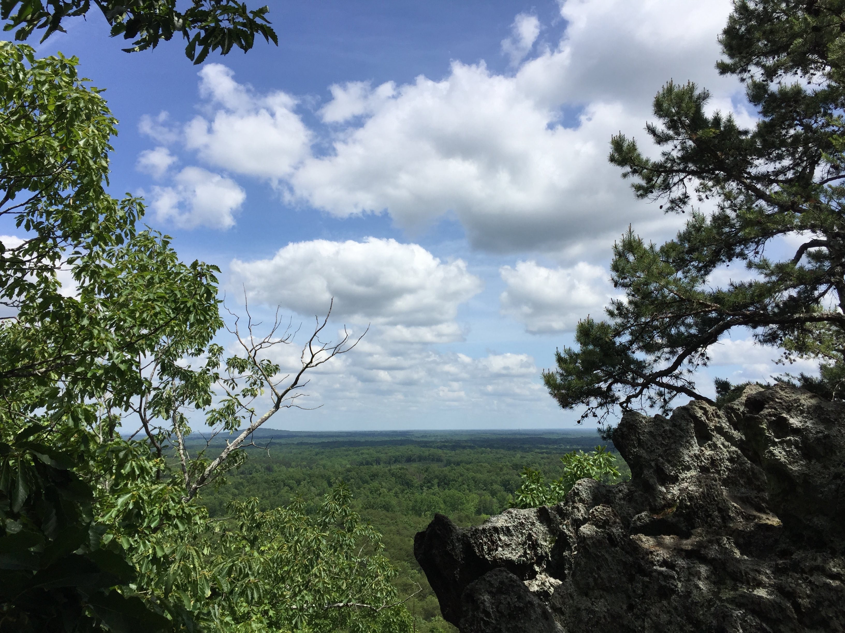
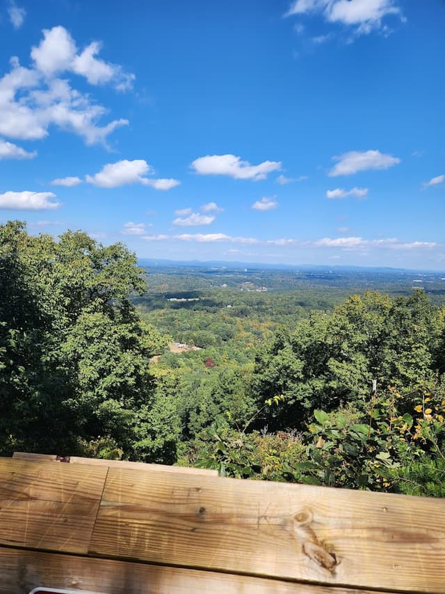
Pinnacle Trail at Crowders Mountain
-Distance from CLT: 60 minutes
-Trail Length: 4.2 miles
-Elevation gain: 777 feet
-Route type: Out & back
Pinnacle Trail at Crowders Mountain
@lindseyamiller
✨Trail Magic✨ - VISTAS! On clear days, there are views of The Blue Ridge Mountains, the Charlotte skyline, and the rolling Piedmont region of NC. Stick around at the summit for a STUNNING sunset view!

Details
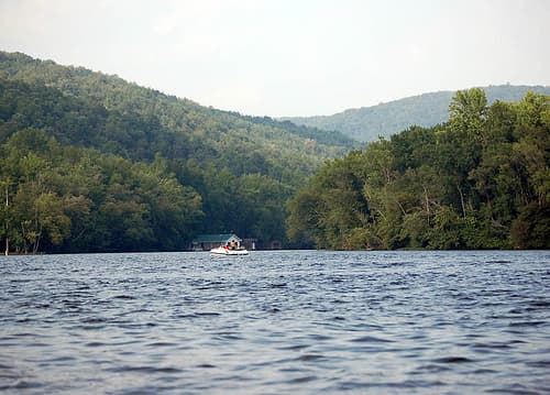
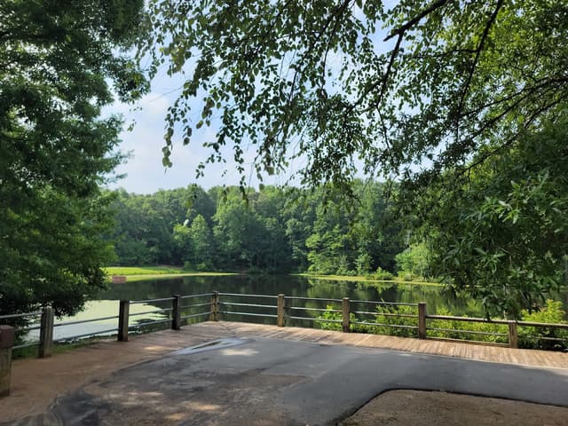
Riverbend Park Red Trail at Riverbend Park
-Distance from CLT: 1 hour 5 mins
-Trail Length: 3.5 miles
-Elevation gain: 311 feet
-Route type: Loop
Riverbend Park Red Trail at Riverbend Park
@lindseyamiller
✨Trail Magic✨ - RIVER + WILDLIFE! Hike along the Catawba River and the dense upland forest to see the many different types of wildlife along the way: turtles, herons, snakes, and sometimes deer and hawks too! Make a day of it and head out on the water in kayaks, SUPs, or canoes.
Details
Bakers Mountian Loop Trail at Bakers Mountain Park
-Distance from CLT: 1 hour 10 mins
-Trail Length: 2.3 miles
-Elevation gain: 534 feet
-Route type: Loop
Bakers Mountian Loop Trail at Bakers Mountain Park
@lindseyamiller
✨Trail Magic✨ - VISTAS! A wonderfully wooded trail with creek hops, and a former farmhouse chimney ruin guides you to a peak with a viewing platform and great views of the foothills of the Blue Ridge Mountains.
Details
Badin Lake Trail at The Uwharrie National Forest
-Distance from CLT: 1 hour 10 mins
-Trail Length: 5.3 miles
-Elevation gain: 311 feet
-Route type: Loop
Badin Lake Trail at The Uwharrie National Forest
@lindseyamiller
✨Trail Magic✨ - LAKE VIEWS! Hike in this quiet, lesser-known National Forest and for beautiful scenery and views of Badin Lake. Fall time in the Uwharrie is beautiful, so be sure to plan your visit in the later months if you can.
Details
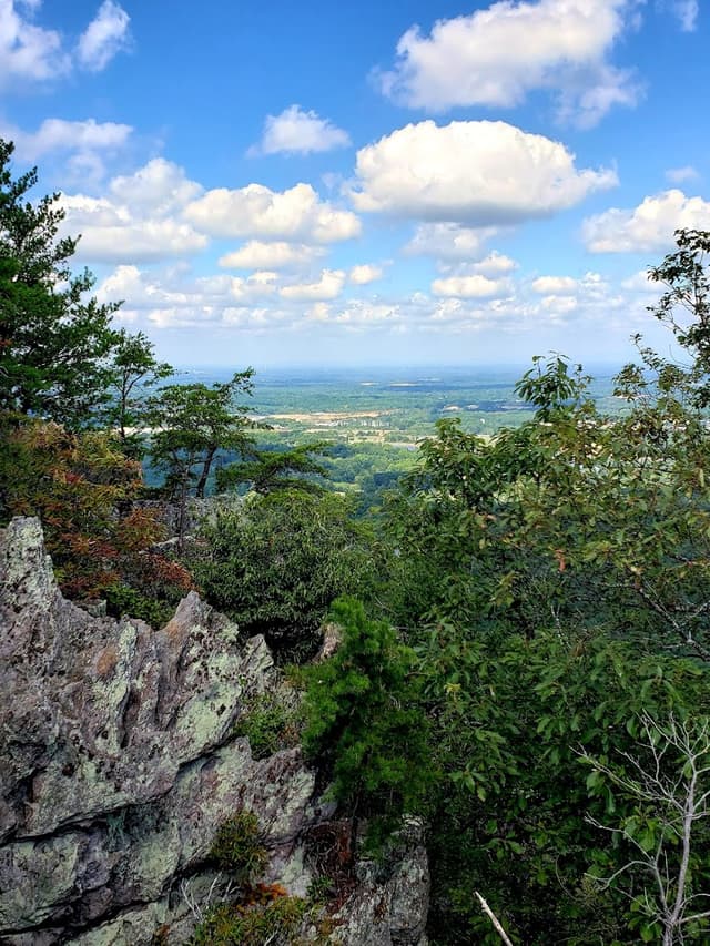
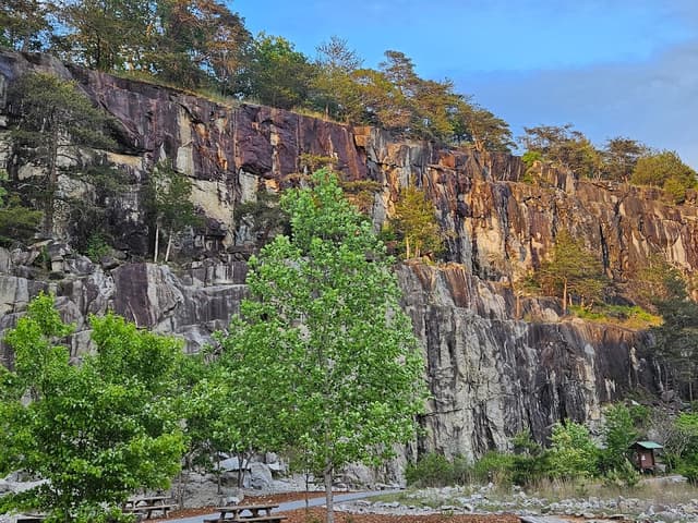
Hollow Rock Trail at Rocky Face Mountain Recreational Area
-Distance from CLT: 1 hour 10 mins
-Trail Length: 3.1 miles
-Elevation gain: 688 feet
-Route type: Loop
Hollow Rock Trail at Rocky Face Mountain Recreational Area
@lindseyamiller
✨Trail Magic✨ - A GRANITE DOME + CLIMBING! Hike this MASSIVE granite dome bald which was also the site of a former quarry operation. You can view remnants of the operations at the base of the mountain where participate or just watch as qualified climbers tackle the cliff faces.
Details
Lake Norman Lakeshore Trail
-Distance from CLT - 1 hour 20 mins
-Trail Length - 6.1 miles
-Elevation gain - 387 feet
-Route type - Loop
Lake Shore Trail at Lake Norman
@lindseyamiller
✨Trail Magic✨ - LAKE VIEWS! A great way to view the unique forested shoreline of Lake Norman. There are even some shallow shoals to walk out and view the water.
Details
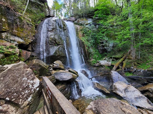
High Shoals Falls Loop Trail at South Mountains State Park
-Distance from CLT - 1 hour 20 mins
-Trail Length - 2.4 miles
-Elevation gain - 557 feet
-Route type - Loop
High Shoals Falls Loop Trail at South Mountains State Park
@lindseyamiller
✨Trail Magic✨ - WATERFALL! A winding creek full of boulders and pools leads you to a beautiful, cascading 80' waterfall. Climb the stairs to the viewing platform to feel the spray from the water pouring off the rocks. Summit the stairs to see the serene headwaters before they plunge over the waterfall.
Details
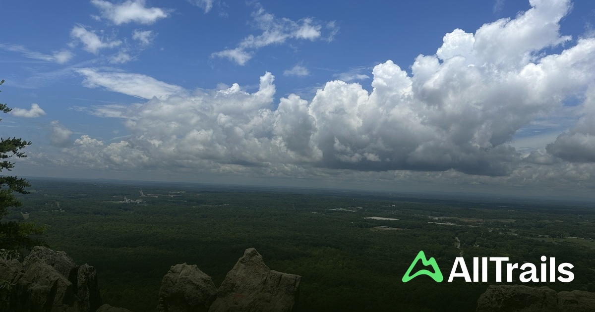
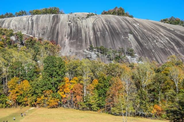
Stone Mountain Trail at Stone Mountain State Park
-Distance from CLT - 1 hour 30 mins
-Trail Length - 3.4 miles
-Elevation gain - 521 feet
-Route type - Out & Back
Stone Mountain Trail at Stone Mountain State Park
@lindseyamiller
✨Trail Magic✨ - A GRANITE DOME! Hike one of the magnificent granite dome balds of North Carolina with views of the Blue Ridge Mountain and Piedmont regions. Take a break at the top and find a cozy rock pocket for a restful sit.
Details
Hikes Less than 60 mins from CLT—
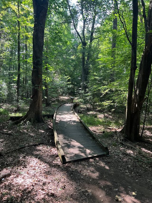
Reedy Creek Nature Preserve Trail
-Distance from CLT - 25 mins
-Trail Length - 2.8 miles
-Elevation gain - 190 feet
-Route type - Loop
Reedy Creek Nature Preserve Trail
@lindseyamiller
✨Trail Magic✨ - HISTORICAL RUINS + POND VIEWS! This easy-access trail is close to the city but a world away. Hike through forests and creeks, alongside a pond and discover an old farmhouse ruin. Pack a picnic, play at the kid's playground, or visit the Nature Center to make a day of it.
Details
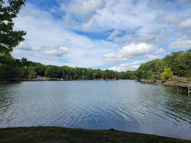
McDowell Nature Preserve: Cove, Cedar Ridge, Creekside and Chestnut Trail
-Distance from CLT - 30 mins
-Trail Length - 4.5 miles
-Elevation gain - 456 feet
-Route type - Loop
McDowell Nature Preserve: Cove, Cedar Ridge, Creekside and Chestnut Trail
@lindseyamiller
✨Trail Magic✨ - LAKE VIEWS + WILDLIFE! This trail winds through acres of forest and borders Lake Wylie. Catch lake views, hop creeks, see old-growth trees, and view wildlife such as herons, hawks, osprey, deer, and the occasional snake. Visit The Nature Center for more wildlife viewings and education.
Details
Seven Oaks Preserve Trail Loop from South New Hope Road
-Distance from CLT - 40 mins
-Trail Length - 4.9 miles
-Elevation gain - 216 feet
-Route type - Loop
Seven Oaks Preserve Trail
@lindseyamiller
✨Trail Magic✨ - LAKE VIEWS + NATURE PRESERVE - This easy hike takes you alongside a tree-lined cove in Lake Wylie. Follow the trail into the Daniel Stowe Botanical Garden for a glimpse at local flora.
Details
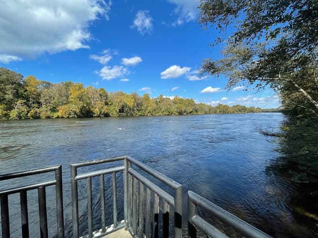
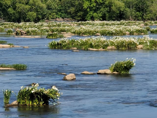
Landsford Canal Trail at Landsford Canal State Park
-Distance from CLT - 45 mins
-Trail Length - 3.0 miles
-Elevation gain - 45 feet
-Route type - Out & Back
Landsford Canal Trail at Landsford Canal State Park
@lindseyamiller
✨Trail Magic✨ - RIVER VIEWS + RUINS + RARE FLOWERS! Hike alongside and inside the well-preserved ruins of a canal system that moved goods down the Catawba River in the 1800s. See beautiful river views and keep an eye out for the rare Spider Lily Plant during the month of May. The plants grow in the rocky shoals in the middle of the river and people come from all over to view the rare flowers!
Details
Nanny’s Mountain Trailhead
-Distance from CLT - 45 mins
-Trail Length - 1.8 miles
-Elevation gain - 239 feet
-Route type - Out & Back
Nanny’s Mountain Trailhead
@lindseyamiller
✨Trail Magic✨ - HISTORICAL SITE + VISTAS! Hike this small mountain to see the remnants of a Revolutionary War-era iron mine as well as views Lake Wylie and the Charlotte Skyline.
Details
Mineral Springs Greenway
-Distance from CLT - 50 mins
-Trail Length - 3.5 miles
-Elevation gain - 98 feet
-Route type - Out & Back
Mineral Springs Greenway
@lindseyamiller
✨Trail Magic✨ - CREEK VIEWS + MILL RUINS! This is an easy, family-friendly hike alongside a quiet creek and beautiful forest. Keep your eyes peeled and you may discover the remnants of an old mill pond and dam.
Details
* * *