The Prettiest Hikes in California
Save for Later
Share
The Prettiest Hikes in California
Ro | California and beyond!
Available for hire
10 prettiest hikes in California with trail length, parking, best time to go, tips never shared and Google Map links! From Northern to Southern California!
Updated ago
1
Share
Northern California
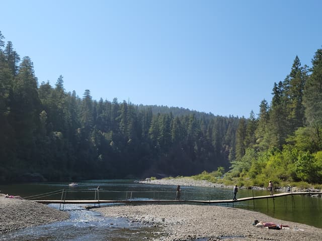
Stout Grove Trailhead
@roinwanderlust
Why: The bridge above the clear river is so beautiful!
Length: short 0.5 mile
Parking: Small lot. I used Howland Hill Rd to get to the lot. The road is unpaved.
Best time to go: Summer so you can picnic, paddle, and swim at the beach next to Smith River
Google Maps: https://maps.app.goo.gl/814ncLUDCHhbdbYj8
Add to
Details
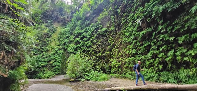
Fern Canyon Trail
@roinwanderlust
Why: You're surrounded by massive walls of Fern and walk through a stream with wooden boards
Length: 1 mile loop, but 11-mile round trip to Fern Canyon from the Prairie Creek Visitor Center without any permit
Parking: There is a Fern Canyon parking area, but to get there you need to cross two streams. If you're driving a low-clearance vehicle you will most likely get stuck. Also, Davison Road (a dirt road) is not good for large recreational vehicles or anything towing a trailer.
Reservations: Usually required during the summer
Best Time to Go: June to September when wooden footbridges are usually installed
Tips:
-Roosevelt Elk are common in the area to the trail. Do not approach them as it's very dangerous.
-Wear water shoes with good grip. Your shoes will get wet!
-Download the area on Google Maps so you can have access offline
Google Maps: https://maps.app.goo.gl/e7vecaRZTaJRuYVi8
Add to
Details
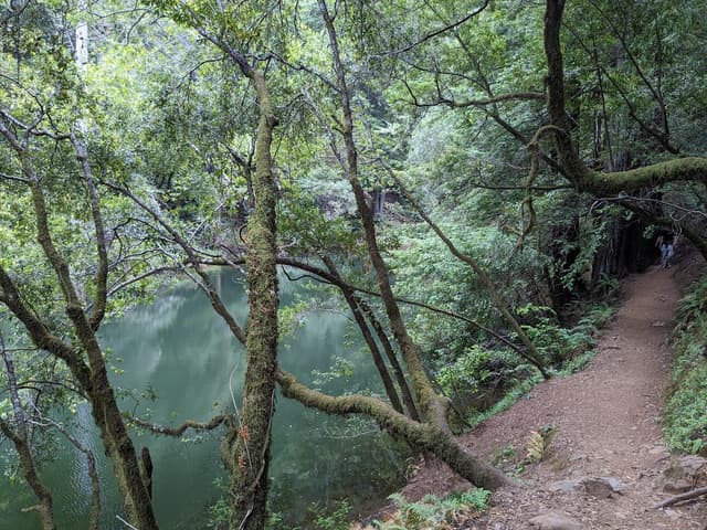
Cataract Falls
@roinwanderlust
Why: The water shed is surrounded by beautiful trees and the stairs and bridges to the falls adds to the wooden scenery
Length: 3 miles out-and-back, 7.5 miles loop
Parking: At the trailhead is limited on Bolinas-Fairfax Road. Others suggest parking at Laurel Dell Picnic Area (at the top of the trail)
Best Time to Go: In my opinion, all year round. But if you want to see the waterfall flowing, go after the winter or spring rains
Tips:
-Wear sturdy and comfy shoes. The trail can get steep and has switchbacks
-Download the area on Google Maps so you can have access offline
Google Maps: https://maps.app.goo.gl/DyCU6M2cpGziX9hx7
Add to
Details
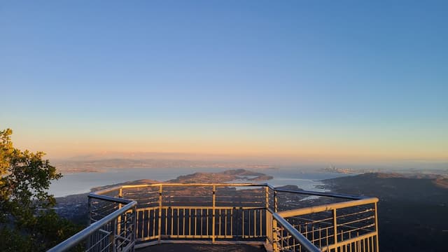
Mount Tamalpais East Peak
@roinwanderlust
Trail: Verna Dunshee Trail
Why: You get 360 views of the SF Bay Area way high up at the Observation Deck
Length: 0.7 mile, paved trail
Parking: Available at the East peak trail head
Best Time to Go: In my opinion, all year round. But if you want to see the hills of Mount Tam green, go after the winter or spring rains
Tips:
-Trail starts on left after entering from parking lot
-You can find other dirt trails along the way
-Check out the Gardner Fire Lookout while you're there (trail is a little more challenging)
-Download the area on Google Maps so you can have access offline
Google Maps: https://maps.app.goo.gl/KTz6XzKr6fkrCrAd8
Add to
Details
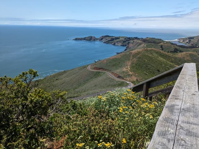
Hawk Hill
@roinwanderlust
Why: You get a view of the Golden Gate Bridge, the coast and the ocean. It's also close to many challenging trails.
Length: 0.20 miles round-trip
Parking: Limited parking right in front on Conzelman Road. You can also try parking on the Coastal Trail Parking and carefully walk along Conzelman Road.
Best Time to Go: In my opinion, all year round
Tips:
-If you want a longer and more challenging hike, also do the 7.3 mi Hawk Hill, Kirby Cove, and Battery Spencer (https://www.alltrails.com/trail/us/california/golden-gate-gems-hawk-hill-kirby-cove-and-battery-spencer)
-Download the area on Google Maps so you can have access offline
Google Maps: https://maps.app.goo.gl/Q6PdjekFer1yjKB46
Add to
Details
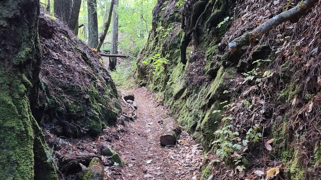
Fall Creek Trail
@roinwanderlust
Why: The trail goes a long a beautiful creek and is surrounded by redwoods.
Length: 3.5-mile loop if you continue on Lime Kilns Trail (https://www.alltrails.com/trail/us/california/fall-creek-to-lime-kilns-trail)
Parking: Limited parking when coming in from Felton Empire Road. Some cars were parked along Felton Empire Road.
Best Time to Go: In my opinion, all year round. But if you want to see the creek flowing go after the winter or spring rains.
Tips:
-It can get muddy, so wear the right shoes.
-There were some downed trees, but it's easy to navigate through
-Download the area on Google Maps so you can have access offline
Google Maps: https://maps.app.goo.gl/ZEAK8eu5u9mkA43g6
Add to
Details

Buy to unlock full guide
Access all the local insights and recommendations from @roinwanderlust when you purchase this guide.
ABOUT THE AUTHOR
Ro | California and beyond!
Available for hire
Need help planning your trip? You’ve come to the right place.
My travels are highly researched and filled with good food, sightseeing, culture, history and amazing places.
With 70K+ followers on social media, I have become a trusted source for travel information.
I offer pre-made itineraries and travel consultation calls, curated list of recommendations, and personalized guides.
I’ll help you look for restaurants, activities and offer hotel recommendations. It’s worth it because I’ll do all the research work for you, so you can save time and energy!
I’m based in California! I know it the most but I also have traveled to many places, like Japan, Thailand, Vietnam, Canada and Mexico!
What's included
Digital Map
Fully interactive, digital map for finding places nearby
10 places
10 hand-picked places with notes from the creator
FOCUSES AND THEMES
Female Solo
Family
Groups
Couples
Plus Size
Adventure
Outdoors
Relaxation
Road Trip
Photography
Van Life
Format
Map
Maps are simple lists of places often grouped by themes, categories or geos.
COMMON QUESTIONS
What is Thatch?
Thatch is an online marketplace that provides instant access to thousands of vetted local experts and premium travel guides - making it the easiest and most affordable way to take high quality trips with less stress.
For travel creators (tastemakers, travel advisors, influencers and local experts) Thatch makes it easy to curate, publish, and sell digital travel guides, itineraries and personalized planning services.
What if I’m not satisfied with my purchase?
How do I access my purchased guides?
Can I access my guide offline?
How often are guides updated?
Can I request a personalized guide or itinerary?
Can I sell my own travel guides and itineraries?
Save for Later
Share