Cathedral Valley Loop, Capitol Reef National Park, Utah
Save for Later
Share
Cathedral Valley Loop, Capitol Reef National Park, Utah
Sarah and Tim | Organized Adventurer
This meticulously crafted interactive map showcases an extensive stop-by-stop driving route through Cathedral Valley in Capitol Reef National Park, Utah, featuring 25 handpicked locations, along with detailed information about each site. With the Cathedral Valley Scenic Drive Map, your exploration becomes a curated and unforgettable experience, guiding you through the awe-inspiring landscapes of Cathedral Valley, the rainbow-colored Bentonite Hills, and the glistening Glass Mountain.
Updated ago
Save
Share
Stop-by-Stop

Fremont River Ford (Mile 0)
@organized_adventurer
Your Cathedral Valley Loop driving adventure starts at mile marker 91 on Highway 24, when you leave the pavement behind and cross the Fremont River. You will definitely need 4x4 and high clearance to drive the Cathedral Valley Loop, and the Fremont River crossing is one of the reasons why. The ford is usually passable, but may be impassable during spring runoff or after a big rain storm. Water levels are usually 8-16 inches deep. When you enter the ford, turn immediately right. Stay on the right half of the river, which is usually shallower. In about 100 feet, make a sharp left onto the bank.
Add to
Details
Blue Flats (Mile 3.5)
@organized_adventurer
After about 3 miles, the landscape opens up to a valley known as Blue Flats. If you look at the rocks around the valley, you'll notice the layers are tilted. Geologists call this a syncline, and it's the same phenomenon that created the Waterpocket Fold for which Capitol Reef National Park is famous.
Add to
Details
BLM Road 0826 Junction Oasis (Mile 6)
@organized_adventurer
You'll know you've arrived at the junction of Hartnet Road and BLM Road 0826 when you see the rusted out drilling truck. Ranchers created this artificial oasis as a water supply for their cattle. Don't drink this water, though - it's untreated.
Add to
Details
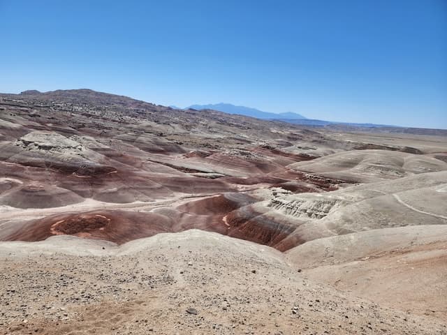
Bentonite Hills (Mile 8.5)
@organized_adventurer
The Bentonite Hills are one of our favorite geologic wonders of Capitol Reef National Park because of their colorful stripes. You can think of these as Utah's very own rainbow hills. Geologically, what you're looking at here is the Brushy Basin Layer of the Morrison Formation. What this means is that this clay soil originated from volcanic ash mud about 150 million years ago. The Bentonite clay becomes very sticky and goopy when wet, making travel on foot or by car basically impossible. So, you should avoid the Bentonite Hills when wet or stormy weather is forecasted.
Add to
Details
Lower South Desert Overlook (Mile 15)
@organized_adventurer
The Lower South Desert Overlook is reached by a very short walk from the parking area, which is located on a 1.2 mile-long spur road. The hike is about a half mile round trip to a scenic view over the South Desert. To the west, you'll see Jailhouse Rock, a large Entrada Sandstone monolith, which, for perspective, is standing about 520 feet above the valley floor.
Add to
Details
Ackland Spring (Mile 22)
@organized_adventurer
You may notice a trickle of water around this area. This is Ackland Spring, a rare source of water in the area. This was also an area where cattle access drinking water, but again, you shouldn't drink it without purification.
Add to
Details
Upper South Desert Overlook (Mile 29)
@organized_adventurer
Another short spur road leads to a parking area and trailhead for a half-mile round trip walk to the Upper South Desert Overlook. At this overlook, you will see the same valley you saw at the Lower South Desert Overlook (Mile 15), but from a different direction and vantage point.
Add to
Details

Buy to unlock full guide
Access all the local insights and recommendations from @organized_adventurer when you purchase this guide.
ABOUT THE AUTHOR
Sarah and Tim | Organized Adventurer
Hey! We're Sarah and Tim, avid travelers and adventurous souls who love helping you plan your dream bucket list adventures. We've traveled to over 70 countries across all 7 continents, and have been spending the last few years roadtripping the US. We developed these curated guides and itineraries to help you experience the beauty of the world. Enjoy!
What's included
Digital Map
Fully interactive, digital map for finding places nearby
25 places
25 hand-picked places with notes from the creator
DESTINATION(S) COVERED
Capitol Reef National Park, Utah, USA
Cathedral Valley, Utah, USA
USA
Utah, USA
FOCUSES AND THEMES
Adventure
Nature
Road Trip
Format
DIY Tour
Self-guided tours are self-paced, stop-by-stop experiences like a food crawls or history walks.
COMMON QUESTIONS
What is Thatch?
Thatch is an online marketplace that provides instant access to thousands of vetted local experts and premium travel guides - making it the easiest and most affordable way to take high quality trips with less stress.
For travel creators (tastemakers, travel advisors, influencers and local experts) Thatch makes it easy to curate, publish, and sell digital travel guides, itineraries and personalized planning services.
What if I’m not satisfied with my purchase?
How do I access my purchased guides?
Can I access my guide offline?
How often are guides updated?
Can I request a personalized guide or itinerary?
Can I sell my own travel guides and itineraries?
Save for Later
Share