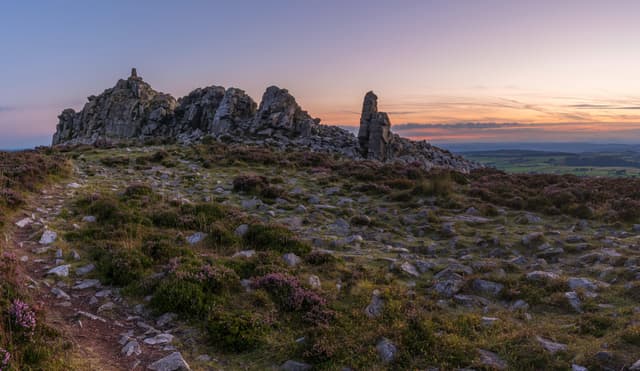
1. Stiperstones
Stiperstones’ Manstone Rock summit stands at 536m. The hill range is characterised by rugged, jagged mounds of Quartzite rock, formed some 480 million years ago during the ice age. Legend has it that The Devils Chair, the second highest peak of Stiperstones was created by the Devil himself who was planning to use a load of rocks to fill in the valley on the other side of Stiperstones known as Hell’s Gutter. The Devil is said to have stopped for a rest at the top of Stiperstones. When he got up, he tripped and one of his apron strings ripped, leading to him dropping the rocks and lazily leaving them there! I wonder what he was cooking prior to his evil plan taking hold!? It is said that witches and evil spirits continue to meet with the Devil when the rocks are covered by clouds. He sits on his chair atop the hill, where they discuss all things evil.
Stiperstones
@janire
There are various routes to get to the summit depending on where you park. The easiest hiking trail is from the Knolls car park postcode: SY5 0NL which is closest to the summit. You can also park at The Bog car park postcode: SY5 0NG which adds an additional walk either along the road or up through the fields to get to the trail for Stiperstones to the left or to Nipstone to the right. Make sure you are wearing good boots as much of these trails are over rocky, uneven terrain. My favourite route to the top of Stiperstones however is from Snailbeach. There is a steep climb through the forest and a long walk to get to the main rock formations, but this trail has the best views and is more of a ‘hike’. You can park at Snailbeach village hall car park postcode: SY5 0NX, there is an honesty box by the toilets where donations are welcomed. Pre Covid-19, the village hall would often be open on a Sunday serving hot and cold drinks as well as cakes and other snacks, perfect to warm cold hands and fill empty tummies after a long walk or ride.
Stiperstones is a National Nature Reserve and known for the beautiful purple Heather and wildlife including red grouse. The area used to be owned in the 11th century by Wild Edric, a Saxon noble. When the Normans invaded England he fought hard to defend his land, however lost the battle eventually and had to make peace with William the Conqueror. Legend states that for his failure to defend his land he was imprisoned in the lead mines by the witches and remains there to this day. If you see the ghost of Wild Edric galloping on his horse across the hills, it means war is imminent. In addition to hiking up to Stiperstones why not also take a walk around the disused lead mine buildings at Snailbeach and learn a little bit about it’s history?

Details
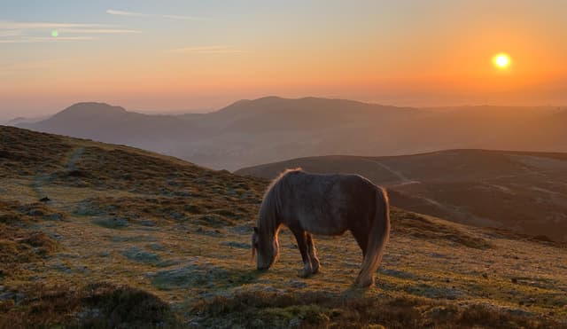
2. The Long Mynd
The Long Mynd in Church Stretton is easily my second favourite hill in Shropshire due to the beautiful wild Welsh mountain ponies that roam freely in the area. It is such a delight to see them with their foals year-round. They appear to be quite used to people and often come right up close if you have food on you. They quite like a munch on a juicy apple, though this is not advised as it may cause them health and behavioural problems. The Long Mynd is about 11km long and has an area of 54km squared.
Long Mynd
@janire
The Long Mynd has various peaks the highest of which is Pole Bank at 516m. You can park at Carding Mill Valley, National Trust car park postcode: SY6 6JG which costs £7 a day for non-members. You can alternatively park within the town and walk your way there or drive up The Burway Road to the top for an easier hike. There are various routes through Cardingmill Valley, one takes you to the Pool Hollow reservoir where children and families like to take a dip in the summer when it’s hot and hardcore wild swimmers go even in winter. Further along the route you can veer left, along the stream towards Light Spout Waterfall, a lovely 4m fall. This trail is rocky and can be tricky in places. There is an alternative route to the right for an easier trail to the top of the hill.
Shooting Box is one of sixteen Bronze Age burial mounds on the Mynd, named after a grouse shooting hut that used to stand on the land until 1992. Shooting Box is a rare bell barrow that dates to 1950-1700BC. It isn’t far from The Portway, a Neolithic route taken by traders some 5000 years ago, to avoid the wet valleys below. If you like stargazing, the Milky Way can be seen from this area of the Long Mynd. On top of the hills is a gliding club and it is quite a sight to watch them take off. The hills are also popular with mountain bikers with trails to excite and challenge all level riders.
Church Stretton is a lovely little town to explore after a long walk with plenty of pubs and restaurants for a well-deserved meal and beer post hike.
Details
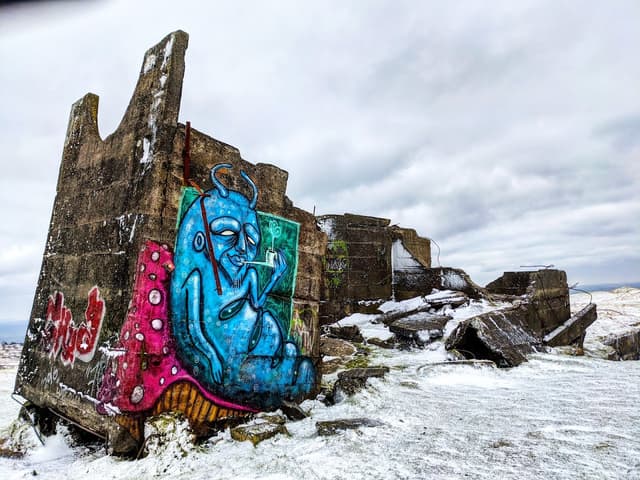
3. Titterstone Clee Hill
Titterstone Clee Hill has both working and disused quarries. Many of the disused quarry buildings have been covered in beautiful graffiti art and it’s great fun to explore them all to see what you can find. It is also host to several radar domes and towers which look like giant golf balls and give the area a surreal and ethereal feel. The largest of the domes is part of the National Air Traffic Services radar network which monitors aircraft over a 100 mile radius. The smaller of the 2 domes is a Met Office radar station.Titterstone Clee has a long history of human activity dating back to the Bronze Age with evidence of cairns and a hillfort near the trig point believed to be over 4000 years old. If you are into a bit of myth and legend, you will know that all giants need a hill to live under in the cold and to lay upon in the summer. The giant of Clee hill was said to be big and boastful and would sit on his chair calling over and making fun of the giants of Abdon Burf and Clee Brown leading to great war between them, remnants of which can be seen all over the local hills. Head towards the rocky outcrop that is the “The Giants Chair” to rest your feet and take in the brilliant views over southern Shropshire.
Titterstone Clee Hill
@janire
Titterstone Clee is such a gem! Rising to 533m, it is the third highest Shropshire hill. It is formed of Dhustone, a carboniferous dark dolerite rock that was used in the construction of the docks of Cardiff. You can drive to the main viewpoint which has free parking postcode: SY8 3NY following the track up Dhustone Road. From here the walk is accessible for those less able or with younger children. If you fancy a bit of a hike to the top, park in Cleehill itself which has a free car park just off the A4117 nearest postcode: SY8 3NA.
Details
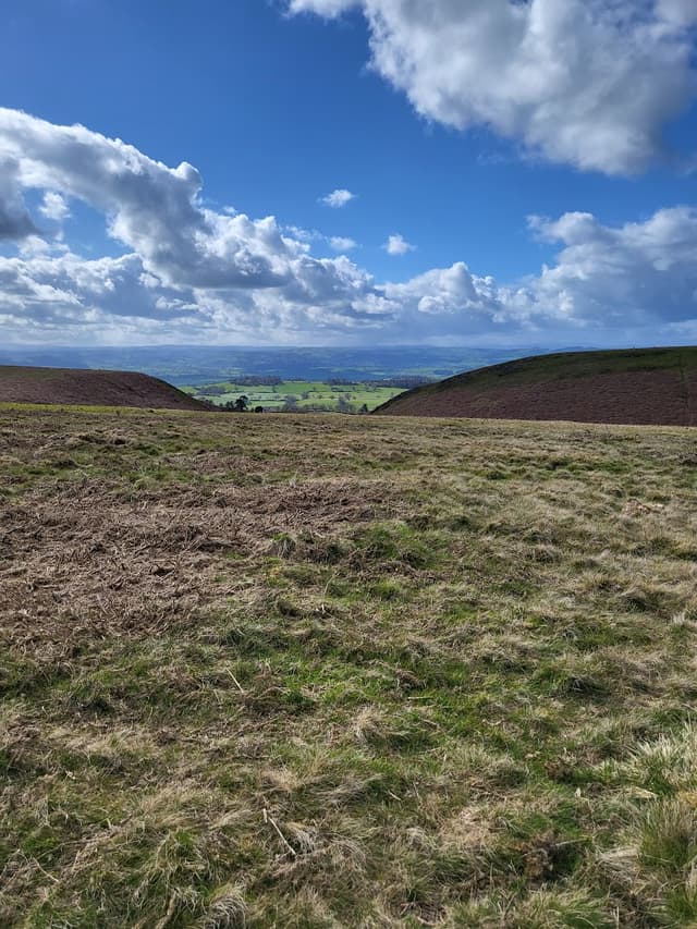
4. Stapeley Hill
Stapeley Hill reaches 402m. This is a gentle, family friendly walk in south Shropshire. I tend to park at Bromlow and follow the trails through the forest but there is parking at Mitchell’s Fold nearest postcode: SY15 6DE. Stapeley Hill is home to Mitchell’s Fold, a Bronze age stone circle and several cairns. Built over 3000 years ago, there used to be 30 stones but only 14 remain standing in a circle with one in the middle. It is certainly no Stone Henge, but definitely worth a visit if you’re in the area. Legend has it that during a time of famine, a passing fairy gave the local people a magic cow that provided an endless supply of milk. One night an evil witch milked her into a sieve. When the cow realised the trick, she disappeared. The witch was turned to stone and a circle of stones were erected around her, to ensure that she could not escape. Cows are definitely drawn to the stones and use the largest one as a scratching post, probably taunting the witch.
Stapeley Hill
@janire
Stapeley Hill has amazing views of Stiperstones to the east. Just over the border in Wales, Corndon Hill 513m and its neighbours LLan Fawr 426m and Roundton 370m are a short walk from Mitchell’s fold. The views from the summit of Corndon Hill were definitely worth the steep climb. Paragliders sometimes take off from the top of Corndon hill. Nearby at Cwm Mawr, there used to be a Bronze Age axe factory where heavy picrite basalt rock was used to make axe-hammers and battle axes, which have been excavated locally and across southern Britain.
Details
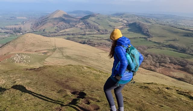
5. Caer Caradoc
There are 2 Caer Caradocs in Shropshire, 1 in Church Stretton and 1 at Chapel Lawn. Caer Caradoc, Church Stretton reaches 459m. I like it because the ridge looks like the backbone of some giant creature that’s been buried under the earth, the official term for which is a ‘whaleback ridge’. You can park just outside Church Stretton on the layby to the left of the B4371 (as you drive out of the town). The south walk from here takes you up the south side of Caer Caradoc and is very steep, although I have seen people running up it! Something that made me feel totally inadequate for being out of breath from just walking it! The north walk from Cardington is much gentler although still not an easy climb.
Caer Caradoc
@janire
Caer Caradoc is volcanic in origin and means ‘The fort of Caradog’ in Welsh. There is an ancient Iron Age hillfort and cave near the summit. Legend has it that this was where Caractacus was defeated by Roman legions during their conquest of Britain and that he hid in the cave when the fort was captured. The cave is also linked to the legend of King Arthur with it being said that the Cauldron of Di-Wrnach, which contains the treasures of Britain and a magical sword, is hidden within the cave. Why not take a look and see if you can find it? There are stunning views of Shropshire from the summit. Nearby are several other good hills to hike; The Lawley, Hope Bowdler and Ragleth Hill which can be done together or separately depending on how tired you want to be at the end of the day!
Details
As you hike through these beautiful hills, take the time to appreciate the delicate balance of nature and the fascinating stories that have shaped these landscapes over millennia. Let the tales of the Devil's Chair, the ancient stone circles, and the local giant's fuel your imagination.
* * *